IMAGES TAKEN NEAR TO
Main Street, NEWPORT, NP11 4PT
Introduction
This page details the photographs taken nearby to Main Street, NP11 4PT by members of the Geograph project.
The Geograph project started in 2005 with the aim of publishing, organising and preserving representative images for every square kilometre of Great Britain, Ireland and the Isle of Man.

There are currently over 7.5m images from over14,400 individuals and you can help contribute to the project by visiting https://www.geograph.org.uk
Image Map
Images are licensed for reuse under creativecommons.org/licenses/by-sa/2.0
Notes
- Clicking on the map will re-center to the selected point.
- The higher the marker number, the further away the image location is from the centre of the postcode.
Image Listing (126 Images Found)
Images are licensed for reuse under creativecommons.org/licenses/by-sa/2.0
Image
Details
Distance
1
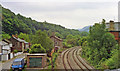
Site of Crumlin (Low Level) station, 1990
View southward, towards Newport, on the then freight only (to Ebbw Vale) Newport - Ebbw Vale/Brynmawr (Western Valleys) line. The station had been closed to passengers when the service ceased on 30/4/62 but remained for goods until 7/11/66, and freight trains continued to Ebbw Vale until 5/7/02. The line was restored for a Cardiff - Ebbw Vale passenger service from 6/2/08, but no new station has been provided here. (Cf. Image]).
Image: © Ben Brooksbank
Taken: 19 May 1990
0.01 miles

3
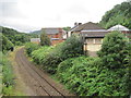
Crumlin (Low Level) railway station (site), Gwent
Opened in 1850 by the Monmouthshire Railway & Canal Company on the line from Newport (Gwent) to Ebbw Vale (which at opening was just a rudimentary industrial tramway), this station was largely constructed c.1857. It closed in 1962.
View south towards Newbridge and Newport. The street level building is still extant to the right and the pale part of the structure appears to be part of the old footbridge. The celebrated Crumlin viaduct would have been behind (and high above!) the photographer.
Image: © Nigel Thompson
Taken: 18 Aug 2012
0.02 miles
4
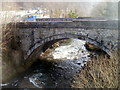
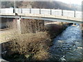
Stone bridge across the Ebbw, Crumlin
The bridge carries a footpath from the A467 on the left, across the River Ebbw, to Crumlin Square.
Image: © Jaggery
Taken: 17 Feb 2011
0.02 miles
5
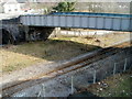
Bridge over a railway line, Crumlin
The bridge carries a footpath (from the A467 to Crumlin Square) over the single-track Ebbw Valley line, between Newbridge and Llanhilleth stations. On the left, a stone bridge http://www.geograph.org.uk/photo/2713152 conveys the footpath over the River Ebbw.
Image: © Jaggery
Taken: 17 Feb 2011
0.02 miles
6
Eastern side of Kendon Road bridge, Crumlin
Viewed from a footbridge. http://www.geograph.org.uk/photo/2713163
The bridge carries the B4251 (here named Kendon Road) over the River Ebbw and a railway line. http://www.geograph.org.uk/photo/2751346
Image: © Jaggery
Taken: 17 Feb 2011
0.02 miles
7

Eastern end of Kendon Road, Crumlin
The B4251, here named Kendon Road, approaches a bridge leading to the A467 junction. Turn left ahead for Brynmawr or Ebbw Vale, right for Newport or Pontypool.
The nearer left turn leads to the remains of Crumlin Navigation Colliery buildings.
Image: © Jaggery
Taken: 17 Feb 2011
0.02 miles
8

Eddie Stobart lorry Lauren Louise on the A467, Crumlin
The Volvo lorry passes the B4251 Kendon Road junction. Most Eddie Stobart lorries have female names. This one is named Lauren Louise.
Image: © Jaggery
Taken: 17 Feb 2011
0.02 miles
9
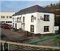
Side view of The Viaduct pub, Crumlin
Viewed from the edge of the A467. For more than 100 years, until demolition in 1967, the 200 feet high Crumlin Viaduct was nearby.
Image: © Jaggery
Taken: 17 Feb 2011
0.02 miles