IMAGES TAKEN NEAR TO
Station Road, NEWPORT, NP11 4PA
Introduction
This page details the photographs taken nearby to Station Road, NP11 4PA by members of the Geograph project.
The Geograph project started in 2005 with the aim of publishing, organising and preserving representative images for every square kilometre of Great Britain, Ireland and the Isle of Man.

There are currently over 7.5m images from over14,400 individuals and you can help contribute to the project by visiting https://www.geograph.org.uk
Image Map
Images are licensed for reuse under creativecommons.org/licenses/by-sa/2.0
Notes
- Clicking on the map will re-center to the selected point.
- The higher the marker number, the further away the image location is from the centre of the postcode.
Image Listing (114 Images Found)
Images are licensed for reuse under creativecommons.org/licenses/by-sa/2.0
Image
Details
Distance
1
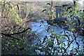
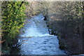
River Ebbw, Station Road, Crumlin
Looking downstream; taken from the riverbank next to the weir Image
Image: © M J Roscoe
Taken: 14 Jan 2016
0.03 miles
2
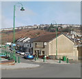
Main Street shops, Crumlin
Beyond green lampposts and posts is a row of shops and business premises on Main Street. Nearest the camera is The Wexa. http://www.geograph.org.uk/photo/2297484
Image: © Jaggery
Taken: 17 Feb 2011
0.04 miles
3
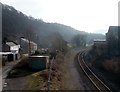
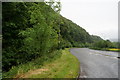
Crumlin : Bend ahead on the Ebbw Valley Line
Viewed from a footbridge. http://www.geograph.org.uk/photo/2713163
The next station in this direction is Newbridge. The houses are on Station Road.
There is no longer a railway station in Crumlin : the Low Level and High Level stations closed in the 1960s.
Image: © Jaggery
Taken: 17 Feb 2011
0.04 miles
5
Ebbw River, Station Road, Crumlin
Image: © M J Roscoe
Taken: 14 Jan 2016
0.05 miles
7
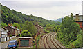
Site of Crumlin (Low Level) station, 1990
View southward, towards Newport, on the then freight only (to Ebbw Vale) Newport - Ebbw Vale/Brynmawr (Western Valleys) line. The station had been closed to passengers when the service ceased on 30/4/62 but remained for goods until 7/11/66, and freight trains continued to Ebbw Vale until 5/7/02. The line was restored for a Cardiff - Ebbw Vale passenger service from 6/2/08, but no new station has been provided here. (Cf. Image]).
Image: © Ben Brooksbank
Taken: 19 May 1990
0.05 miles
8
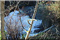
Weir, River Ebbw, Station Road, Crumlin
The river is in full spate after the heavy rains earlier in January. The horizontal grid on the right covers a tributary emerging from a culvert.
Image: © M J Roscoe
Taken: 14 Jan 2016
0.05 miles
9
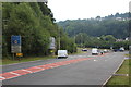
A472/A467 junction, Crumlin
Looking down Hafod-yr-ynys Road, A472, towards the junction which had extra lanes added in 2015.
Image: © M J Roscoe
Taken: 18 Aug 2016
0.05 miles
10
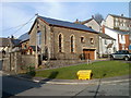
Former St Mary's Church, Crumlin
Located on the corner of Lawn Terrace and Hafodyrynys Road. The former church has been converted into a dwelling named La Campana. The small grey building on the right is Church House.
Image: © Jaggery
Taken: 17 Feb 2011
0.06 miles