IMAGES TAKEN NEAR TO
Maes Gwyn, NEWPORT, NP11 4HU
Introduction
This page details the photographs taken nearby to Maes Gwyn, NP11 4HU by members of the Geograph project.
The Geograph project started in 2005 with the aim of publishing, organising and preserving representative images for every square kilometre of Great Britain, Ireland and the Isle of Man.

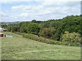
There are currently over 7.5m images from over14,400 individuals and you can help contribute to the project by visiting https://www.geograph.org.uk
Image Map
Images are licensed for reuse under creativecommons.org/licenses/by-sa/2.0
Notes
- Clicking on the map will re-center to the selected point.
- The higher the marker number, the further away the image location is from the centre of the postcode.
Image Listing (77 Images Found)
Images are licensed for reuse under creativecommons.org/licenses/by-sa/2.0
Image
Details
Distance
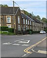
1
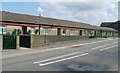
Maesteg bungalows, Pentwynmawr
A long line of bungalows on the north side of High Street, Pentwynmawr, is named Maesteg at the location, though some maps shown Maes Teg.
Image: © Jaggery
Taken: 16 Aug 2010
0.06 miles
2
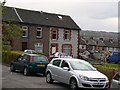
Pentwynmawr village
Traditional terrace houses
Image: © Colin Madge
Taken: 25 Apr 2008
0.07 miles
4
Edmund Place, Pentwynmawr
Houses at the southeast corner of Edmund Place are alongside the northern edge of High Street.
Image: © Jaggery
Taken: 16 Aug 2010
0.07 miles
5
Pentwynmawr : course of a former railway line
Looking NW from the far end of Fox Avenue towards the tree-lined course of a dismantled railway line. The next street along from Fox Avenue is Station Street. http://www.geograph.org.uk/photo/2017277
Image: © Jaggery
Taken: 16 Aug 2010
0.08 miles
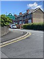
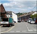
6
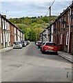
Down Station Street, Pentwynmawr
Station Street houses and cars viewed in May 2022. High Street is behind the camera. Passenger services at Pentwynmawr Halt station ended in 1964.
Image: © Jaggery
Taken: 5 May 2022
0.09 miles
7
Road from Pentwynmawr to Oakdale unsuitable for HGVs
A sign at a left turn on the western edge of Pentwynmawr advises HGV (heavy goods vehicle) drivers to ignore satellite navigation. The 2 kilometre country road north to Oakdale is narrow, bendy and steep, ascending more than 100 metres.
Image: © Jaggery
Taken: 16 Aug 2010
0.10 miles
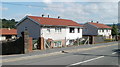
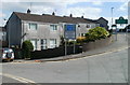
8
Row of stone houses, High Street, Pentwynmawr
The Cae Sheldon junction is on the left.
Image: © Jaggery
Taken: 5 May 2022
0.10 miles
9
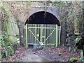
Disused tunnel at Ton-y-pistyll, Newbridge, Caerphilly
The railway between Risca in the Ebbw Valley and Markham Colliery in the Sirhowy Valley passed under the A472 (now unclassified) at Ton-y-pistyll, by means of the 239 yds-long Penar Tunnel. This is the west portal of the tunnel.
Image: © Ralph Rawlinson
Taken: 18 Feb 2006
0.10 miles
10
Station Street, Pentwynmawr
Viewed from High Street.
The railway station and railway have long since disappeared. A few fragments of the railway remain in the area, here and there. http://www.geograph.org.uk/photo/2017399
Image: © Jaggery
Taken: 16 Aug 2010
0.10 miles