IMAGES TAKEN NEAR TO
Strathview, NEWPORT, NP11 4HT
Introduction
This page details the photographs taken nearby to Strathview, NP11 4HT by members of the Geograph project.
The Geograph project started in 2005 with the aim of publishing, organising and preserving representative images for every square kilometre of Great Britain, Ireland and the Isle of Man.

There are currently over 7.5m images from over14,400 individuals and you can help contribute to the project by visiting https://www.geograph.org.uk
Image Map
Images are licensed for reuse under creativecommons.org/licenses/by-sa/2.0
Notes
- Clicking on the map will re-center to the selected point.
- The higher the marker number, the further away the image location is from the centre of the postcode.
Image Listing (68 Images Found)
Images are licensed for reuse under creativecommons.org/licenses/by-sa/2.0
Image
Details
Distance
1
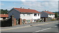
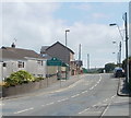
Edmund Place, Pentwynmawr
Houses at the southeast corner of Edmund Place are alongside the northern edge of High Street.
Image: © Jaggery
Taken: 16 Aug 2010
0.03 miles
3
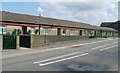
Maesteg bungalows, Pentwynmawr
A long line of bungalows on the north side of High Street, Pentwynmawr, is named Maesteg at the location, though some maps shown Maes Teg.
Image: © Jaggery
Taken: 16 Aug 2010
0.04 miles
4
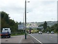
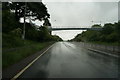
The A472 looking west
This section of the A472 links the Ebbw Valley with the Sirhowy Valley.
Taken from a lay-by and looking towards Pontllanfraith.
Image: © Robin Drayton
Taken: 20 Aug 2009
0.07 miles
5
Western boundary of Pentwynmawr
Newbridge Road, from Pontllanfraith, becomes High Street Pentwynmawr on entering the village.
Image: © Jaggery
Taken: 16 Aug 2010
0.07 miles
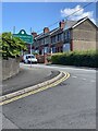
7
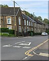
Row of stone houses, High Street, Pentwynmawr
The Cae Sheldon junction is on the left.
Image: © Jaggery
Taken: 5 May 2022
0.08 miles
8
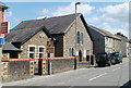
Pentwynmawr Presbyterian Church
Located on High Street. The smaller building (probably the church hall) has
Davies's Memorial
1900
Chapel
inscribed in stone above the windows. The school road sign is for Pentwynmawr Primary School, about 150 metres distant.
Image: © Jaggery
Taken: 16 Aug 2010
0.09 miles
9
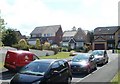
Cae Sheldon, Pentwynmawr
Modern housing on Cae Sheldon viewed from High Street.
Image: © Jaggery
Taken: 16 Aug 2010
0.09 miles
10
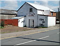
Urban Hair Design, Pentwynmawr
Located on High Street, opposite the turning for Cae Sheldon. http://www.geograph.org.uk/photo/2017265
Barber's shop specialising in hair patterns and designs. 2010 prices on display are "standard gents cut" from £4.50 and "patterns and artwork" from £7.
Image: © Jaggery
Taken: 16 Aug 2010
0.09 miles