1
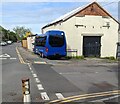
Pentwynmawr Presbyterian Church
Located on High Street. The smaller building (probably the church hall) has
Davies's Memorial
1900
Chapel
inscribed in stone above the windows. The school road sign is for Pentwynmawr Primary School, about 150 metres distant.
Image: © Jaggery
Taken: 16 Aug 2010
0.01 miles
2
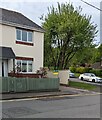
Cae Sheldon, Pentwynmawr
Modern housing on Cae Sheldon viewed from High Street.
Image: © Jaggery
Taken: 16 Aug 2010
0.01 miles
3
Urban Hair Design, Pentwynmawr
Located on High Street, opposite the turning for Cae Sheldon. http://www.geograph.org.uk/photo/2017265
Barber's shop specialising in hair patterns and designs. 2010 prices on display are "standard gents cut" from £4.50 and "patterns and artwork" from £7.
Image: © Jaggery
Taken: 16 Aug 2010
0.01 miles
4
Row of stone houses, High Street, Pentwynmawr
The Cae Sheldon junction is on the left.
Image: © Jaggery
Taken: 5 May 2022
0.02 miles
5
Edmund Place, Pentwynmawr
Houses at the southeast corner of Edmund Place are alongside the northern edge of High Street.
Image: © Jaggery
Taken: 16 Aug 2010
0.05 miles
6
The A472 looking west
This section of the A472 links the Ebbw Valley with the Sirhowy Valley.
Taken from a lay-by and looking towards Pontllanfraith.
Image: © Robin Drayton
Taken: 20 Aug 2009
0.05 miles
7
Three-axle dark blue vehicle, High Street, Pentwynmawr
Parked on the corner of Station Street in May 2022.
Image: © Jaggery
Taken: 5 May 2022
0.05 miles
8
Station Street name sign, Pentwynmawr
On the corner of High Street.
Image: © Jaggery
Taken: 5 May 2022
0.06 miles
9
Plaid Cymru placard, High Street, Pentwynmawr
The placard showing "Plaid Cymru / Party of Wales" is outside a High Street house near the corner of Cae Sheldon on Thursday May 5th 2022. Elections to all wards in all Welsh county & county borough councils and town & community councils are taking place today.
Image: © Jaggery
Taken: 5 May 2022
0.06 miles
10
Bilingual Priority sign, High Street, Pentwynmawr
English / Welsh sign facing westbound traffic.
Image: © Jaggery
Taken: 5 May 2022
0.06 miles


