IMAGES TAKEN NEAR TO
Newbridge, NEWPORT, NP11 4GN
Introduction
This page details the photographs taken nearby to NP11 4GN by members of the Geograph project.
The Geograph project started in 2005 with the aim of publishing, organising and preserving representative images for every square kilometre of Great Britain, Ireland and the Isle of Man.

There are currently over 7.5m images from over14,400 individuals and you can help contribute to the project by visiting https://www.geograph.org.uk
Image Map
Images are licensed for reuse under creativecommons.org/licenses/by-sa/2.0
Notes
- Clicking on the map will re-center to the selected point.
- The higher the marker number, the further away the image location is from the centre of the postcode.
Image Listing (111 Images Found)
Images are licensed for reuse under creativecommons.org/licenses/by-sa/2.0
Image
Details
Distance
1
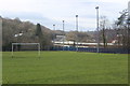
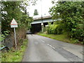
Football pitch by Celynen Viaduct
The dual carriageway, A472, crosses a river Image west of the football pitch, railway line and road before ascending the hill and bypassing Newbridge.
Image: © M J Roscoe
Taken: 13 Mar 2020
0.03 miles
2
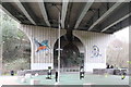
Avian artwork on stanchion of Celynen Viaduct
Kingfisher and goldfinch decorating stanchion next to the railway line.
Image: © M J Roscoe
Taken: 6 Jan 2019
0.03 miles
3
Ebbw valley, Newbridge
Viewed from Celynen Road. A track heads towards the edge of a single-track railway line, south of Newbridge station. http://www.geograph.org.uk/photo/1931261 The flyover carries the A472.
Image: © Jaggery
Taken: 8 Aug 2012
0.03 miles
4
Remains of mineral railway line, Newbridge
A short length of railway line, possibly on the site of an old crossing.
Image: © M J Roscoe
Taken: 11 Mar 2017
0.03 miles
5
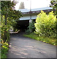
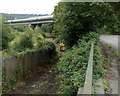
Celynen Road flyover, Newbridge
The flyover carries the A472 over Celynen Road.
Image: © Jaggery
Taken: 18 Sep 2015
0.04 miles
6
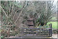
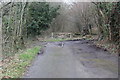
Byway up to Pennar-fach
Restricted byway with steps going up from a former mineral railway, Newbridge; the open gate is for the garden of a private house (out of picture, right)
Image: © M J Roscoe
Taken: 11 Mar 2017
0.05 miles
7
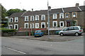
Beynon Street, Newbridge
Numbers 1-5 are at the SE end of Beynon Street, in the SE corner of Newbridge.
Viewed across Celynen Road.
Image: © Jaggery
Taken: 8 Aug 2012
0.06 miles
8
End of the pavement in the SE of Newbridge
Opposite the SE end http://www.geograph.org.uk/photo/3073660 of Beynon Street, a sign alongside Celynen Road shows that there is no footway ahead for ¾ mile. The flyover carries the A472.
Image: © Jaggery
Taken: 8 Aug 2012
0.06 miles
9
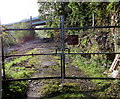
Locked gate to the railway, Newbridge
Accessed along a path from Celynen Road, the gate gives authorised railway staff access to the railway 300 metres south of Newbridge railway station.
Image: © Jaggery
Taken: 18 Sep 2015
0.06 miles
10
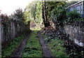
End of a path to a railway gate, Newbridge
From Celynen Road to this http://www.geograph.org.uk/photo/4667812 locked gate.
Image: © Jaggery
Taken: 18 Sep 2015
0.06 miles