1
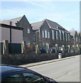
Mining School Hill, Crumlin
The road climbs away from Main Street, heading towards the Crumlin Rathbone centre, which opened in 1976. The centre occupies the former mining school building.
Image: © Jaggery
Taken: 17 Feb 2011
0.04 miles
2
Southern boundary of Crumlin
Viewed along North Road from the northern edge of Newbridge.
Crumlin, population about 6,000, is a town in Caerphilly County Borough.
Image: © Jaggery
Taken: 17 Feb 2011
0.05 miles
3
Marlan Day Centre, Crumlin
Located on the corner of Main Street (on the left) and Crown Street.
The building is the former Crumlin Workmen's Club and Institute. The year 1920 is inscribed in stone near roof level above the doorway.
Image: © Jaggery
Taken: 17 Feb 2011
0.06 miles
4
Crumlin Workmen's Club and Institute
Dated 1920 but now used by a training company for training care workers I believe.
Image: © Jeremy Bolwell
Taken: 14 Oct 2012
0.08 miles
5
Ordnance Survey Cut Mark
This OS cut mark can be found on the wall SE side of North Road. It marks a point 109.167m above mean sea level.
Image: © Adrian Dust
Taken: 11 May 2019
0.09 miles
6
Old Mill in Crumlin
An interesting shape, taking the position at a road junction.
Image: © Graham Horn
Taken: 28 Dec 2007
0.11 miles
7
Ordnance Survey Flush Bracket (S1342)
This OS Flush Bracket can be found on the Old Police House, Crown Street. It marks a point 113.776m above mean sea level.
Image: © Adrian Dust
Taken: 11 May 2019
0.12 miles
8
Treowen
Skate board park in Treowen
Image: © Sally Lloyd
Taken: 5 Jul 2007
0.12 miles
9
Crumlin High Level Primary School
Viewed along Commercial Road. The school, for children aged 3 to 11, has about 230 pupils enrolled.
Image: © Jaggery
Taken: 17 Feb 2011
0.13 miles
10
Ordnance Survey Cut Mark
This OS cut mark can be found on the school wall, Commercial Road. It marks a point 154.491m above mean sea level.
Image: © Adrian Dust
Taken: 11 May 2019
0.13 miles


