1
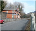
Older housing at Newbridge
On the road from Newbridge to Crumlin in the western part of the square. These older houses are built up away from the road. To the right is the Ebbw Vale railway line, shortly to reopen to passengers.
Image: © Graham Horn
Taken: 28 Dec 2007
0.02 miles
2
The Masons Arms, Newbridge
Located on North Road, the road to Crumlin. The fence is the perimeter of the Ebbw Valley railway.
There has been a pub or inn on this site since the early days of Newbridge. An 1846 map shows the Blacksmiths Arms on the same site.
At the side of the pub, a steep, unnamed, road http://www.geograph.org.uk/photo/2274051 gives pedestrians access between North Road and Greenfield.
Image: © Jaggery
Taken: 17 Feb 2011
0.02 miles
3
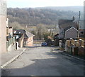
Steep descent from Greenfield, Newbridge
The view from the edge of Greenfield down a steep, unnamed, road giving pedestrians access to North Road. Metal railings prevent vehicular access.
The building at the foot of the hill on the left is the Masons Arms. http://www.geograph.org.uk/photo/2274065
Image: © Jaggery
Taken: 17 Feb 2011
0.02 miles
4
Ordnance Survey Cut Mark
This OS cut mark can be found on the wall of No43 North Road. It marks a point 113.023m above mean sea level.
Image: © Adrian Dust
Taken: 11 May 2019
0.03 miles
5
Tynewydd Primary School, Newbridge
Primary school with about 250 pupils,viewed across a street named Greenfield.
Image: © Jaggery
Taken: 17 Feb 2011
0.07 miles
6
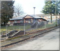
Nursery, Tynewydd Primary School
The nursery building is located on Greenfield, at the northern edge (and highest point) of the primary school http://www.geograph.org.uk/photo/2273660 site.
Image: © Jaggery
Taken: 17 Feb 2011
0.08 miles
7
North along Greenfield, Newbridge
From Ashfield Road. Greenfield Stores http://www.geograph.org.uk/photo/5254078 are on the left.
Image: © Jaggery
Taken: 14 Jan 2017
0.10 miles
8
Church taken from the tech estate
Image: © andy dolman
Taken: 9 Jan 2009
0.11 miles
9
Grade II* listed presbytery, Newbridge
Viewed across Greenfield. The presbytery and adjoining church http://www.geograph.org.uk/photo/2273739 were Grade II* listed in 1999. Shown on maps as Our Lady of Peace Roman Catholic church and presbytery, there were no signs at the site to confirm that this is still the case.
Image: © Jaggery
Taken: 17 Feb 2011
0.12 miles
10
Grade II* listing building, Newbridge
Viewed across Park Road. Shown on maps as Our Lady of Peace Roman Catholic Church, there were no signs at the site to confirm that this is still the case. What is certain is that the Italianate building, dating from the 1930s, has been Grade II* listed since 1999. The attached presbytery (priests' house) http://www.geograph.org.uk/photo/2273746 is included in the listing.
Image: © Jaggery
Taken: 17 Feb 2011
0.12 miles


