IMAGES TAKEN NEAR TO
Crumlin Road, NEWPORT, NP11 3PF
Introduction
This page details the photographs taken nearby to Crumlin Road, NP11 3PF by members of the Geograph project.
The Geograph project started in 2005 with the aim of publishing, organising and preserving representative images for every square kilometre of Great Britain, Ireland and the Isle of Man.

There are currently over 7.5m images from over14,400 individuals and you can help contribute to the project by visiting https://www.geograph.org.uk
Image Map
Images are licensed for reuse under creativecommons.org/licenses/by-sa/2.0
Notes
- Clicking on the map will re-center to the selected point.
- The higher the marker number, the further away the image location is from the centre of the postcode.
Image Listing (133 Images Found)
Images are licensed for reuse under creativecommons.org/licenses/by-sa/2.0
Image
Details
Distance
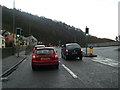
1
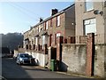
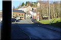
Gladstone Road, Crumlin
Houses on the north side of Gladstone Road, a cul-de-sac connecting with Hafodyrynys Road (behind the camera).
Image: © Jaggery
Taken: 17 Feb 2011
0.02 miles
2
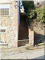
Steps up to Gladstone Road, Crumlin
Viewed from the edge of Bethel Baptist Chapel. http://www.geograph.org.uk/photo/2752214
The steps give a short, steep route from Hafodyrynys Road to Gladstone Road.
Image: © Jaggery
Taken: 17 Feb 2011
0.02 miles
3
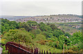
Northward in Ebbw Valley at site of Crumlin Viaduct, 1990
View NE to Swffryd, over the site of the former Crumlin Viaduct, some residual piers of which can be seen. Demolished in 1967, the viaduct carried the ex-GW Pontypool Road (to the right) - Aberdare - Neath line, which was closed on 15/6/1964, across the valley and the Newport - Ebbw Vale/Brynmawr line at Crumlin (Low Level). See Image
Image: © Ben Brooksbank
Taken: 19 May 1990
0.02 miles
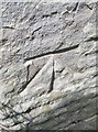
4
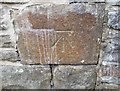
Ordnance Survey Cut Mark
This OS cut mark can be found on the wall west side of Crumlin Road. It marks a point 125.160m above mean sea level.
Image: © Adrian Dust
Taken: 11 May 2019
0.03 miles
6
Ordnance Survey Cut Mark
This OS cut mark can be found on the east angle of St Mary's Church. It marks a point 127.553m above mean sea level.
Image: © Adrian Dust
Taken: 11 May 2019
0.04 miles
7
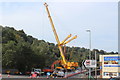
Crane on A467 by River Ebbw
The crane is being readied to lift part of the railway bridge which spans the river Image
Image: © M J Roscoe
Taken: 19 Sep 2020
0.04 miles
8
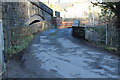
Stone bridge, River Ebbw, Station Road, Crumlin
An early road bridge over the river. The bridge to its left carries a later road, now only a footpath, over the river and railway behind the camera. The brick wall on the far side of the bridge is a retaining wall for the A467. The rectangular plaque on the northern parapet is inscribed, 'Mynyddislwyn Highway District MR 1886'.
Image: © M J Roscoe
Taken: 14 Jan 2016
0.04 miles
9
Station Road, Crumlin
Taken from the eastern entrance to the road tunnel under the A467. The stone building with a brown door and windows is now a house, formerly St Mary's Church.
Image: © M J Roscoe
Taken: 14 Jan 2016
0.04 miles
10
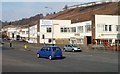
Viaduct Buildings, Crumlin
Business premises on the east side of the A467. This area was formerly crossed by the Crumlin Viaduct, which at 200 feet was the highest railway viaduct ever built in the British Isles. In 1962, the viaduct was scheduled by the Ministry of Housing and Local Government as a structure of architectural and historical importance.
However at the time of closure of the viaduct in 1964, this decision was overruled by British Railways, who decided that demolition was needed, partly because the viaduct needed continuing regular maintenance (despite the line being closed) and partly because the structure was deemed to be in a dangerous state of disrepair. Dismantling of the viaduct was completed in 1967.
Image: © Jaggery
Taken: 17 Feb 2011
0.05 miles