IMAGES TAKEN NEAR TO
Pentwyn Road, NEWPORT, NP11 3LN
Introduction
This page details the photographs taken nearby to Pentwyn Road, NP11 3LN by members of the Geograph project.
The Geograph project started in 2005 with the aim of publishing, organising and preserving representative images for every square kilometre of Great Britain, Ireland and the Isle of Man.

There are currently over 7.5m images from over14,400 individuals and you can help contribute to the project by visiting https://www.geograph.org.uk
Image Map
Images are licensed for reuse under creativecommons.org/licenses/by-sa/2.0
Notes
- Clicking on the map will re-center to the selected point.
- The higher the marker number, the further away the image location is from the centre of the postcode.
Image Listing (87 Images Found)
Images are licensed for reuse under creativecommons.org/licenses/by-sa/2.0
Image
Details
Distance
1
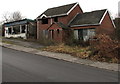
Derelict buildings, Pentwyn Road, Trinant
Viewed in December 2016. A September 2011 Google Earth Street View shows similar dereliction.
Image: © Jaggery
Taken: 19 Dec 2016
0.02 miles
2
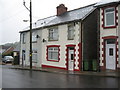
Older houses in Trinant
These houses are on Pentwyn Road. Most of the houses in Trinant are Council Houses, or ex-Council Houses, but these are some which pre-date those.
Image: © Jessica Aidley
Taken: 5 Jul 2007
0.04 miles
3
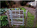
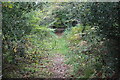
Kissing gate to a public footpath, Trinant
Between Pentwyn Road and this http://www.geograph.org.uk/photo/5231769 public footpath.
Image: © Jaggery
Taken: 19 Dec 2016
0.07 miles
4
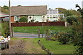
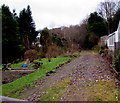
Track to Pentwyn Road, Trinant
The track alongside a garden is also the course of a public footpath Image
Image: © M J Roscoe
Taken: 5 Oct 2018
0.07 miles
5
Public footpath on the west side of Pentwyn Road, Trinant
Accessed through a kissing gate. http://www.geograph.org.uk/photo/5231771
Image: © Jaggery
Taken: 19 Dec 2016
0.07 miles
6
Path up to Cefn-coch-isaf
Public footpath, alongside garden, on gated track from Pentwyn Road, Trinant.
Image: © M J Roscoe
Taken: 18 Mar 2017
0.07 miles
7
Woodland Drive, Trinant
Cul-de-sac on the east side of Pentwyn Road.
Image: © Jaggery
Taken: 19 Dec 2016
0.07 miles
8
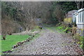
Track west of Pentwyn Road, Trinant
This section of the track carries a public footpath. At the far end of the track it turns left to head towards Pentwyn Road Image
Image: © M J Roscoe
Taken: 5 Oct 2018
0.08 miles
9
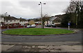
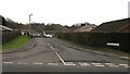
North side of a grassy roundabout, Pentwyn
In the middle of the V shaped junction of Pentwyn Road and Trinant Terrace.
Image: © Jaggery
Taken: 19 Dec 2016
0.09 miles
10
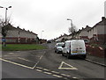
Junction of Pentwyn Road and Trinant Terrace, Pentwyn
Viewed from Pentwyn Road.
Image: © Jaggery
Taken: 19 Dec 2016
0.09 miles