IMAGES TAKEN NEAR TO
Marshfield Road, NEWPORT, NP11 3JL
Introduction
This page details the photographs taken nearby to Marshfield Road, NP11 3JL by members of the Geograph project.
The Geograph project started in 2005 with the aim of publishing, organising and preserving representative images for every square kilometre of Great Britain, Ireland and the Isle of Man.

There are currently over 7.5m images from over14,400 individuals and you can help contribute to the project by visiting https://www.geograph.org.uk
Image Map
Images are licensed for reuse under creativecommons.org/licenses/by-sa/2.0
Notes
- Clicking on the map will re-center to the selected point.
- The higher the marker number, the further away the image location is from the centre of the postcode.
Image Listing (75 Images Found)
Images are licensed for reuse under creativecommons.org/licenses/by-sa/2.0
Image
Details
Distance
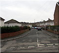
1
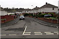
Marshfield Road, Pentwyn
From Llanerch Road along Marshfield Road towards Trinant Terrace.
Image: © Jaggery
Taken: 19 Dec 2016
0.01 miles
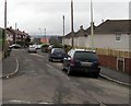
2
Up Llanerch Road, Pentwyn
Llanerch Road ascends from Penywaun Road.
Image: © Jaggery
Taken: 19 Dec 2016
0.02 miles
3
Llanerch Road speed bump, Pentwyn
Painted white triangles draw attention to the speed bump across Llanerch Road.
The Belvedere Close http://www.geograph.org.uk/photo/5229772 junction is on the right.
Image: © Jaggery
Taken: 19 Dec 2016
0.04 miles
4
Western end of Penywaun Road, Pentwyn
Looking east along Penywaun Road from Trinant Terrace.
Image: © Jaggery
Taken: 19 Dec 2016
0.05 miles
5
Belvedere Close, Pentwyn
Cul-de-sac on the west side of Llanerch Road.
Image: © Jaggery
Taken: 19 Dec 2016
0.05 miles
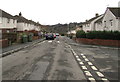
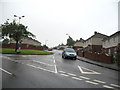
6
Llanerch Road, Pentwyn
Viewed from Conway Road. Llanerch Road extends for 200 metres to Penywaun Road.
Image: © Jaggery
Taken: 19 Dec 2016
0.05 miles
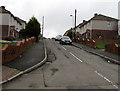
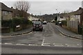
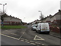
7
Trinant Terrace
The junction of Pentwyn Road and Trinant Terrace. This junction includes sections of one-way road, so that you turn into Trinant Terrace beyond the green area shown in this picture. The houses in Trinant Terrace were built as Council Houses.
Image: © Jessica Aidley
Taken: 5 Jul 2007
0.05 miles
8
Osbo(u)rne Road, Pentwyn
Cul-de-sac on the east side of Penywaun Road.
The name sign nearer the camera shows OSBOURNE RD.
The smaller sign on the wall shows OSBORNE ROAD.
Image: © Jaggery
Taken: 19 Dec 2016
0.06 miles
9
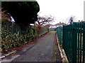
Path towards Trinant Terrace, Pentwyn
From Pentwyn Terrace.
Image: © Jaggery
Taken: 19 Dec 2016
0.06 miles
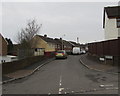
10
Junction of Pentwyn Road and Trinant Terrace, Pentwyn
Viewed from Pentwyn Road.
Image: © Jaggery
Taken: 19 Dec 2016
0.06 miles