IMAGES TAKEN NEAR TO
Fflorens Road, NEWPORT, NP11 3DU
Introduction
This page details the photographs taken nearby to Fflorens Road, NP11 3DU by members of the Geograph project.
The Geograph project started in 2005 with the aim of publishing, organising and preserving representative images for every square kilometre of Great Britain, Ireland and the Isle of Man.

There are currently over 7.5m images from over14,400 individuals and you can help contribute to the project by visiting https://www.geograph.org.uk
Image Map
Images are licensed for reuse under creativecommons.org/licenses/by-sa/2.0
Notes
- Clicking on the map will re-center to the selected point.
- The higher the marker number, the further away the image location is from the centre of the postcode.
Image Listing (53 Images Found)
Images are licensed for reuse under creativecommons.org/licenses/by-sa/2.0
Image
Details
Distance
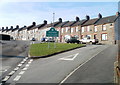
1
Treowen Road, Treowen
View from Parry Terrace.
Image: © Jaggery
Taken: 17 Feb 2011
0.02 miles
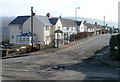
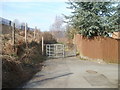
2
Western end of Parry Terrace, Treowen
Parry Terrace houses are on the left. On the right are the edges of houses on streets at right angle to Parry Terrace. The No Entry sign on the right is on the corner of Fflorens Road. http://www.geograph.org.uk/photo/2299755
Image: © Jaggery
Taken: 17 Feb 2011
0.04 miles
3
Albertina Road, Treowen
Viewed from the Parry Terrace end.
Image: © Jaggery
Taken: 17 Feb 2011
0.04 miles
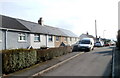
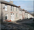
4
Fflorens Road, Treowen
Viewed from Parry Terrace.
Image: © Jaggery
Taken: 17 Feb 2011
0.04 miles
5
Kissing gate between William Street, Treowen and Rhiw Farm Crescent, Rhiw
The path runs along the edge of Crumlin cricket ground. http://www.geograph.org.uk/photo/2299928
Image: © Jaggery
Taken: 17 Feb 2011
0.06 miles
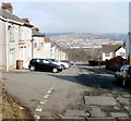
6
Parry Terrace, Treowen
At the top of the long climb up from Crumlin, the road (named Hillside) http://www.geograph.org.uk/photo/2297560 approaches the Treowen boundary, and Parry Terrace.
Image: © Jaggery
Taken: 17 Feb 2011
0.07 miles
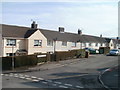
7
William Street, Treowen
Houses on the NE side of the street.
Image: © Jaggery
Taken: 17 Feb 2011
0.07 miles
8
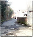
Lane from Parry Terrace to William Street, Treowen
An unnamed lane connects Parry Terrace http://www.geograph.org.uk/photo/2299160 (behind the camera) with William Street. It runs along the eastern edge of Crumlin cricket ground. http://www.geograph.org.uk/photo/2299928
Image: © Jaggery
Taken: 17 Feb 2011
0.07 miles
9
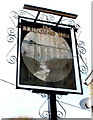
Crumlin Viaduct depicted in The Bridgend Inn sign
The Inn's http://www.geograph.org.uk/photo/2299107 sign depicts the Crumlin Viaduct, which opened in 1857 and closed in 1964. At 200 feet high at the highest point above the valley floor, and 1650 feet long (two spans, 1066 feet and 584 feet), it was the highest railway viaduct in Great Britain throughout its working existence. It was built by the contractor T. W. Kennard. The pub is on the corner of Kennard Terrace.
Image: © Jaggery
Taken: 17 Feb 2011
0.08 miles
10
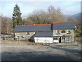
The Bridgend Inn, Crumlin
Inn dating from 1820, http://www.geograph.org.uk/photo/2299116 located on the corner of Kennard Terrace and Hillside.
Image: © Jaggery
Taken: 17 Feb 2011
0.08 miles