IMAGES TAKEN NEAR TO
Ael-y-Bryn Terrace, NEWPORT, NP11 3DG
Introduction
This page details the photographs taken nearby to Ael-y-Bryn Terrace, NP11 3DG by members of the Geograph project.
The Geograph project started in 2005 with the aim of publishing, organising and preserving representative images for every square kilometre of Great Britain, Ireland and the Isle of Man.

There are currently over 7.5m images from over14,400 individuals and you can help contribute to the project by visiting https://www.geograph.org.uk
Image Map
Images are licensed for reuse under creativecommons.org/licenses/by-sa/2.0
Notes
- Clicking on the map will re-center to the selected point.
- The higher the marker number, the further away the image location is from the centre of the postcode.
Image Listing (38 Images Found)
Images are licensed for reuse under creativecommons.org/licenses/by-sa/2.0
Image
Details
Distance
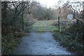
1
Gate at end of Bryn-Deri Terrace, Old Treowen
The gate bars access to a track. A notice on the gate discourages access, but there is a kissing gate on the right of the gate.
Image: © M J Roscoe
Taken: 23 Jan 2021
0.05 miles
2
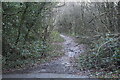
Woodland path, Old Treowen
Path on probably the former track bed of a tramroad serving the defunct Bush Colliery.
Image: © M J Roscoe
Taken: 23 Jan 2021
0.09 miles
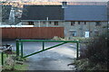
3
Gated track, Old Treowen
The track appears to be on the former track bed of the tramroad serving the defunct Bush Colliery which was beyond the gate. The round notice states that it is private with no entry, but there is an open kissing gate below the notice.
Image: © M J Roscoe
Taken: 23 Jan 2021
0.11 miles
4
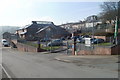
Tynewydd Primary School, Newbridge
Primary school with about 250 pupils,viewed across a street named Greenfield.
Image: © Jaggery
Taken: 17 Feb 2011
0.13 miles
5
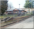
Nursery, Tynewydd Primary School
The nursery building is located on Greenfield, at the northern edge (and highest point) of the primary school http://www.geograph.org.uk/photo/2273660 site.
Image: © Jaggery
Taken: 17 Feb 2011
0.13 miles
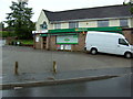
6
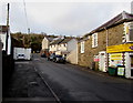
Ashfield Road, Newbridge
Looking NW along Ashfield Road from the Greenfield junction. Greenfield Stores http://www.geograph.org.uk/photo/5254078 are on the right.
Image: © Jaggery
Taken: 14 Jan 2017
0.14 miles
7
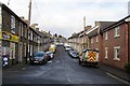
North along Greenfield, Newbridge
From Ashfield Road. Greenfield Stores http://www.geograph.org.uk/photo/5254078 are on the left.
Image: © Jaggery
Taken: 14 Jan 2017
0.15 miles
8
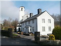
Grade II* listed presbytery, Newbridge
Viewed across Greenfield. The presbytery and adjoining church http://www.geograph.org.uk/photo/2273739 were Grade II* listed in 1999. Shown on maps as Our Lady of Peace Roman Catholic church and presbytery, there were no signs at the site to confirm that this is still the case.
Image: © Jaggery
Taken: 17 Feb 2011
0.16 miles
9
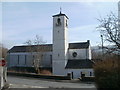
Grade II* listing building, Newbridge
Viewed across Park Road. Shown on maps as Our Lady of Peace Roman Catholic Church, there were no signs at the site to confirm that this is still the case. What is certain is that the Italianate building, dating from the 1930s, has been Grade II* listed since 1999. The attached presbytery (priests' house) http://www.geograph.org.uk/photo/2273746 is included in the listing.
Image: © Jaggery
Taken: 17 Feb 2011
0.16 miles