IMAGES TAKEN NEAR TO
Cil-y-Coed, NEWPORT, NP11 3AQ
Introduction
This page details the photographs taken nearby to Cil-y-Coed, NP11 3AQ by members of the Geograph project.
The Geograph project started in 2005 with the aim of publishing, organising and preserving representative images for every square kilometre of Great Britain, Ireland and the Isle of Man.

There are currently over 7.5m images from over14,400 individuals and you can help contribute to the project by visiting https://www.geograph.org.uk
Image Map
Images are licensed for reuse under creativecommons.org/licenses/by-sa/2.0
Notes
- Clicking on the map will re-center to the selected point.
- The higher the marker number, the further away the image location is from the centre of the postcode.
Image Listing (39 Images Found)
Images are licensed for reuse under creativecommons.org/licenses/by-sa/2.0
Image
Details
Distance
1
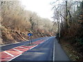
Keep left on the long descent through Cwm Kendon to Crumlin
The B4251, here named Kendon Road, descends ESE towards Crumlin, through a wood named Cwm Kendon. An arrow sign directs traffic to the left side of the carriageway.
Image: © Jaggery
Taken: 17 Feb 2011
0.03 miles
2
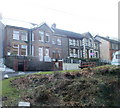
Junction of Woodview Terrace and Kennard Terrace, Crumlin
Viewed along an unnamed road from William Street http://www.geograph.org.uk/photo/2300010 Treowen. Ahead are houses on Woodview Terrace. The western end of Kennard Terrace is on the right.
Image: © Jaggery
Taken: 17 Feb 2011
0.03 miles
3
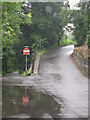
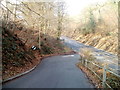
Road junction leading to Rhiw
This photograph was taken on July 5th 2007, following the wettest June on record, and shows that it was still raining and the water was not able to all run away.
Image: © Jessica Aidley
Taken: 5 Jul 2007
0.04 miles
4
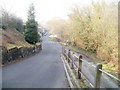
Two routes to the Bridgend Inn, Crumlin
Walkers arriving here from Kendon Road behind the camera can choose the road on the left for a flat walk to the Bridgend Inn http://www.geograph.org.uk/photo/2299107 via Kennard Terrace, or the road on the right for a steepish walk through the central part of the village of Rhiw.
Motorists of course have only one choice.
Image: © Jaggery
Taken: 17 Feb 2011
0.06 miles
5
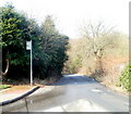
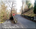
Rhiw Farm Crescent bus stop, Crumlin
Located at the eastern edge of Rhiw Farm Crescent. http://www.geograph.org.uk/photo/2328320
The sign shows that the stop is served by two routes: Service 52 to Abertillery and N2 to central Crumlin.
Image: © Jaggery
Taken: 17 Feb 2011
0.06 miles
6
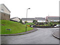
Rhiw Farm Crescent
Small housing estate.
Image: © Jessica Aidley
Taken: 5 Jul 2007
0.07 miles
7
Road from Rhiw reaches Kendon Road, Crumlin
Behind the camera is the village of Rhiw; ahead is Kendon Road (B4251).
Image: © Jaggery
Taken: 17 Feb 2011
0.09 miles
8
Lawrence Villas, Crumlin
A separately named and numbered row of four houses at the eastern end of Woodview Terrace.
Image: © Jaggery
Taken: 17 Feb 2011
0.09 miles
9
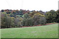
Field under transmission lines, Load of Hay Lane
This is part of the same field on the upper slope of Cwm Kendon seen in Image
Image: © M J Roscoe
Taken: 23 Oct 2015
0.10 miles
10
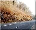
Keep in low gear : 7% descent ahead on the approach to Crumlin
About 500 metres from the junction with the A467(ahead), a sign on the side of Kendon Road (B4251) shows there is a 7% (1 in 14) descent ahead.
Image: © Jaggery
Taken: 17 Feb 2011
0.11 miles