IMAGES TAKEN NEAR TO
Clifton Street, NP10 9QD
Introduction
This page details the photographs taken nearby to Clifton Street, NP10 9QD by members of the Geograph project.
The Geograph project started in 2005 with the aim of publishing, organising and preserving representative images for every square kilometre of Great Britain, Ireland and the Isle of Man.

There are currently over 7.5m images from over14,400 individuals and you can help contribute to the project by visiting https://www.geograph.org.uk
Image Map
Images are licensed for reuse under creativecommons.org/licenses/by-sa/2.0
Notes
- Clicking on the map will re-center to the selected point.
- The higher the marker number, the further away the image location is from the centre of the postcode.
Image Listing (80 Images Found)
Images are licensed for reuse under creativecommons.org/licenses/by-sa/2.0
Image
Details
Distance
1
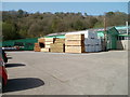
Pontymister sawmills
This is the southern side of T.G. Howell & Sons Ltd sawmills, located at the top of Clifton Street.http://www.geograph.org.uk/photo/1749099
Image: © Jaggery
Taken: 10 Apr 2011
0.01 miles

4
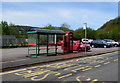
Herbert Avenue street furniture, Pontymister
A postbox and phonebox are alongside a bus shelter. The bus stop is for buses to Risca via Ty Sign. A plate on the back of the phonebox records the name of its manufacturer - W McFarlane & Co Ltd, Saracen Foundry, Glasgow.
Image: © Jaggery
Taken: 30 Apr 2018
0.04 miles
5
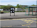
Risca East Community Council noticeboard in Pontymister
Located near a Herbert Avenue bus stop and shelter viewed in April 2018.
The noticeboard is not in this http://www.geograph.org.uk/photo/1749111 March 2010 photo of the same location.
Image: © Jaggery
Taken: 30 Apr 2018
0.05 miles
6
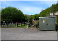
Herbert Avenue electricity substation, Pontymister
Located at the edge of a car park near a children's play area,
the cabinet is a Western Power Distribution electricity substation.
Its identifier is HERBERT AVE. PONTYMISTER S/S 531231.
A plate on the cabinet shows WODEN TRANSFORMER BILSTON ENGLAND.
Image: © Jaggery
Taken: 30 Apr 2018
0.05 miles
7

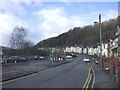
Up Clifton Street, Pontymister
Dead-end Clifton Street ascends from Herbert Avenue towards sawmills and a short row of houses.
Image: © Jaggery
Taken: 30 Apr 2018
0.06 miles
8
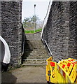
Steps up to Herbert Avenue, Pontymister
From the pavement at the edge of the B4591 Newport Road.
The white edge of a pedestrian tunnel portal https://www.geograph.org.uk/photo/5757083 is on the left.
Image: © Jaggery
Taken: 30 Apr 2018
0.07 miles
9
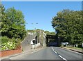
Railway bridge over Newport Road, Rogerstone
Image: © David Smith
Taken: 24 Sep 2021
0.07 miles
10

Strolling along the towpath
Monmouthshire and Brecon Canal.
Image: © Alan Hughes
Taken: 5 Oct 2023
0.07 miles