IMAGES TAKEN NEAR TO
Llandegfedd Close, NEWPORT, NP10 9HP
Introduction
This page details the photographs taken nearby to Llandegfedd Close, NP10 9HP by members of the Geograph project.
The Geograph project started in 2005 with the aim of publishing, organising and preserving representative images for every square kilometre of Great Britain, Ireland and the Isle of Man.

There are currently over 7.5m images from over14,400 individuals and you can help contribute to the project by visiting https://www.geograph.org.uk
Image Map
Images are licensed for reuse under creativecommons.org/licenses/by-sa/2.0
Notes
- Clicking on the map will re-center to the selected point.
- The higher the marker number, the further away the image location is from the centre of the postcode.
Image Listing (59 Images Found)
Images are licensed for reuse under creativecommons.org/licenses/by-sa/2.0
Image
Details
Distance
1
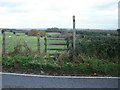
Stile , Cwm Lane
The stile gives access from Cwm Lane to a public right of way (as stated on the notice on the post on the right) that runs northeastwards alongside a field hedge.
Image: © Jaggery
Taken: 19 Nov 2009
0.05 miles
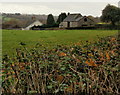
2
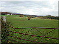
Sheep grazing, Cwm Farm
The view from the edge of Cwm Lane across a field close to Cwm Farm.
Image: © Jaggery
Taken: 19 Nov 2009
0.06 miles
3
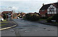
Llangorse Drive, Rogerstone, Newport
Viewed across Bala Drive. This is the NW junction of the two roads.
They meet again about 350 metres to the SE.
Image: © Jaggery
Taken: 23 Jan 2014
0.09 miles
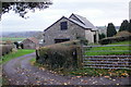
5
Edge of Cwm Farm from Cwm Lane
The view towards Cwm Farm from a substantial hedge on the edge of Cwm Lane.
Image: © Jaggery
Taken: 19 Nov 2009
0.11 miles
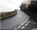
6
20 to 30 along Bala Drive, Rogerstone, Newport
The 20mph speed limit along Groes Road http://www.geograph.org.uk/photo/3943930 increases to 30mph.
Image: © Jaggery
Taken: 23 Jan 2014
0.13 miles
7
NW end of Cwm Lane, Rogerstone, Newport
Cwm Lane head SSE towards High Cross, away from Groes Lane.
Image: © Jaggery
Taken: 23 Jan 2014
0.13 miles
8
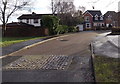
Groes Close, Rogerstone, Newport
Viewed from the Groes Road end, near this http://www.geograph.org.uk/photo/3944328 roundabout.
Image: © Jaggery
Taken: 23 Jan 2014
0.15 miles
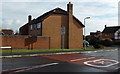
9
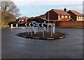
Groes Road roundabout, Rogerstone, Newport
At the crossroads with Bala Drive and the connecting road to Ruskin Avenue.
Image: © Jaggery
Taken: 23 Jan 2014
0.16 miles
10
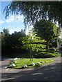
Croesllanfro Roads
White stones line a little green between roads at Croesllanfro. Cwm Lane leads off towards High Cross and Fourteen Locks Canal Centre on the left, Groes Road towards Rogerstone on the right.
Image: © David Roberts
Taken: 12 Sep 2010
0.16 miles