IMAGES TAKEN NEAR TO
Uplands Court, NEWPORT, NP10 9FW
Introduction
This page details the photographs taken nearby to Uplands Court, NP10 9FW by members of the Geograph project.
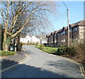
The Geograph project started in 2005 with the aim of publishing, organising and preserving representative images for every square kilometre of Great Britain, Ireland and the Isle of Man.

There are currently over 7.5m images from over14,400 individuals and you can help contribute to the project by visiting https://www.geograph.org.uk
Image Map
Images are licensed for reuse under creativecommons.org/licenses/by-sa/2.0
Notes
- Clicking on the map will re-center to the selected point.
- The higher the marker number, the further away the image location is from the centre of the postcode.
Image Listing (176 Images Found)
Images are licensed for reuse under creativecommons.org/licenses/by-sa/2.0
Image
Details
Distance
1
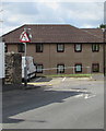
Warning sign - two-way traffic, Bethesda Place, Rogerstone
At the end of the one-way part of the road. A No Entry sign is on the back of this sign.
Uplands Court is in the background.
Image: © Jaggery
Taken: 1 May 2018
0.02 miles
2
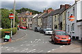
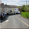
Bethesda Place, Rogerstone
Lower end of the street of colourful small houses, part of the Sirhowy Valley Walk; the upper end of the street from Cefn Road is narrow.
Image: © M J Roscoe
Taken: 10 Jul 2017
0.03 miles
3
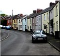
Bethesda Place, Rogerstone
The road ascends towards Cefn Road.
Image: © Jaggery
Taken: 1 May 2018
0.04 miles
4
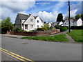
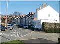
Semis on a Rogerstone corner
Semi-detached houses on the corner of two arms of the road named The Uplands.
Image: © Jaggery
Taken: 1 May 2018
0.05 miles
5
Uplands Court, Rogerstone
On the right side of Wern Terrace is the edge of Uplands Court, built in 1989. It contains 46 flats with a part-time non-resident management staff. There is a community alarm service.
Image: © Jaggery
Taken: 4 Mar 2011
0.05 miles
6
White arrow on Bethesda Place, Rogerstone
Showing the direction of travel for vehicles on this one-way street.
Image: © Jaggery
Taken: 1 May 2018
0.05 miles
7
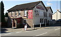
Tredegar Arms, Rogerstone
The Tredegar Arms, located on Cefn Road, has been a pub since about 1800.
Not to be confused with the Tredegar Arms, Bassaleg http://www.geograph.org.uk/photo/1496975 which is little more than a mile away
(less than 2 kilometres).
Image: © Jaggery
Taken: 12 Oct 2009
0.05 miles
8
Bethesda Place, Rogerstone
Viewed from the corner of Wern Terrace. Bethesda Place leads up to Cefn Road and the Tredegar Arms http://www.geograph.org.uk/photo/1664734 but if you are a motorist, you will need to find another route.
Image: © Jaggery
Taken: 4 Mar 2011
0.05 miles
9
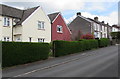
Hedges and houses, Bethesda Place, Rogerstone
On the ascent towards Cefn Road.
Image: © Jaggery
Taken: 1 May 2018
0.06 miles
10
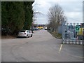
Wern Industrial Estate
Seen from Wern Terrace.
Image: © Michael Dibb
Taken: 10 Mar 2010
0.06 miles