IMAGES TAKEN NEAR TO
Beacons Close, NEWPORT, NP10 9AX
Introduction
This page details the photographs taken nearby to Beacons Close, NP10 9AX by members of the Geograph project.
The Geograph project started in 2005 with the aim of publishing, organising and preserving representative images for every square kilometre of Great Britain, Ireland and the Isle of Man.

There are currently over 7.5m images from over14,400 individuals and you can help contribute to the project by visiting https://www.geograph.org.uk
Image Map
Images are licensed for reuse under creativecommons.org/licenses/by-sa/2.0
Notes
- Clicking on the map will re-center to the selected point.
- The higher the marker number, the further away the image location is from the centre of the postcode.
Image Listing (100 Images Found)
Images are licensed for reuse under creativecommons.org/licenses/by-sa/2.0
Image
Details
Distance
1
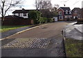
Groes Close, Rogerstone, Newport
Viewed from the Groes Road end, near this http://www.geograph.org.uk/photo/3944328 roundabout.
Image: © Jaggery
Taken: 23 Jan 2014
0.05 miles
2
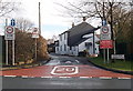
Groes Road, Rogerstone, Newport
Viewed across Ruskin Avenue. There is a 20mph speed limit, no footway for 150 metres
and one-way traffic, away from the camera, along narrow Groes Road.
Image: © Jaggery
Taken: 23 Jan 2014
0.06 miles
3
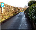
Groes Road, Rogerstone, Newport
Formerly a country road with few houses nearby, Groes Road now connects Ruskin Avenue behind the camera with Bala Drive ahead. There are no pavements here. A 20mph speed is in force and traffic is one way, away from the camera.
Image: © Jaggery
Taken: 23 Jan 2014
0.06 miles
4
Traffic calming on Ruskin Avenue, Rogerstone, Newport
Viewed from the corner of Hunter Close. http://www.geograph.org.uk/photo/3909168 For a few metres, the road narrows to the width of one vehicle. Vehicles on this side have priority over oncoming vehicles. The 30mph speed limit ahead reduces to 20mph on this side, on the approach to the entrance http://www.geograph.org.uk/photo/3909096 to Mount Pleasant Primary School.
Image: © Jaggery
Taken: 23 Jan 2014
0.07 miles
5
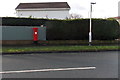
King George V postbox, Ruskin Avenue, Rogerstone, Newport
Located near the corner of Sward Close. A postbox sometimes indicates when the adjacent houses were built, but this is not true here. King George V reigned from May 1910-January 1936. A 1940s map shows that this area was farmland. There was a road nearby at that time, Groes Road, so it seems likely that the postbox was installed for a farming community.
Image: © Jaggery
Taken: 23 Jan 2014
0.07 miles
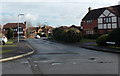
6
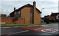
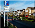
20 to 30 along Bala Drive, Rogerstone, Newport
The 20mph speed limit along Groes Road http://www.geograph.org.uk/photo/3943930 increases to 30mph.
Image: © Jaggery
Taken: 23 Jan 2014
0.08 miles
7
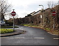
No entry to Groes Road, Rogerstone, Newport
There is one way traffic towards the camera along narrow, pavementless Groes Road.
The car is parked in Groes Close. http://www.geograph.org.uk/photo/3944337
Image: © Jaggery
Taken: 23 Jan 2014
0.08 miles
8
Ruskin Avenue passes Johnston Close, Rogerstone, Newport
Ruskin Avenue, the main road through the Mount Pleasant area of Rogerstone,
passes the left turn for Johnston Close. http://www.geograph.org.uk/photo/3909245
Image: © Jaggery
Taken: 23 Jan 2014
0.08 miles
9
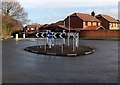
Groes Road roundabout, Rogerstone, Newport
At the crossroads with Bala Drive and the connecting road to Ruskin Avenue.
Image: © Jaggery
Taken: 23 Jan 2014
0.09 miles
10
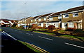
Llangorse Drive, Rogerstone, Newport
Viewed across Bala Drive. This is the NW junction of the two roads.
They meet again about 350 metres to the SE.
Image: © Jaggery
Taken: 23 Jan 2014
0.09 miles