IMAGES TAKEN NEAR TO
Cefn Rise, NEWPORT, NP10 9AR
Introduction
This page details the photographs taken nearby to Cefn Rise, NP10 9AR by members of the Geograph project.
The Geograph project started in 2005 with the aim of publishing, organising and preserving representative images for every square kilometre of Great Britain, Ireland and the Isle of Man.

There are currently over 7.5m images from over14,400 individuals and you can help contribute to the project by visiting https://www.geograph.org.uk
Image Map
Images are licensed for reuse under creativecommons.org/licenses/by-sa/2.0
Notes
- Clicking on the map will re-center to the selected point.
- The higher the marker number, the further away the image location is from the centre of the postcode.
Image Listing (130 Images Found)
Images are licensed for reuse under creativecommons.org/licenses/by-sa/2.0
Image
Details
Distance
1
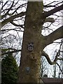
Scary tree
Alongside the towpath of the Monmouthshire & Brecon Canal.
Image: © Michael Dibb
Taken: 10 Mar 2010
0.01 miles
2
![Monmouthshire & Brecon Canal [6]](https://s2.geograph.org.uk/geophotos/01/81/77/1817702_9ce9b2fe_120x120.jpg)
Monmouthshire & Brecon Canal [6]
A scene between the bridges carrying Groes Road and Ruskin Avenue over the canal.
Image: © Michael Dibb
Taken: 10 Mar 2010
0.03 miles
3
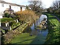
Monmouthshire & Brecon Canal (Crumlin arm)
The view from Image
Image: © Robin Drayton
Taken: 1 Feb 2008
0.03 miles
4
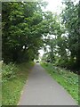
Trees overhanging the shared-use track by Monmouthshire and Brecon Canal
Image: © David Smith
Taken: 25 Sep 2021
0.05 miles
5
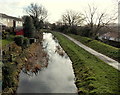
Canal SE of Groes Road bridge, Rogerstone, Newport
Viewed from here http://www.geograph.org.uk/photo/3972753 looking along the disused Monmouthshire and Brecon canal (Crumlin Arm).
Image: © Jaggery
Taken: 23 Jan 2014
0.05 miles
6
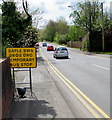
Yellow temporary bus stop sign, Cefn Road, Rogerstone
The sign is in place on May 1st 2018 while the permanent bus stop behind the camera is out of use during roadworks. https://www.geograph.org.uk/photo/5758224 The text is also in Welsh. This stop is for buses to Newport.
Image: © Jaggery
Taken: 1 May 2018
0.05 miles
7
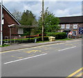
Cefn Road bus stop near the Tredegar Arms, Rogerstone
This stop is for buses to Pontymister, Risca, Blackwood etc. The Tredegar Arms pub https://www.geograph.org.uk/photo/5758079 is on the right.
Image: © Jaggery
Taken: 1 May 2018
0.06 miles
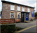
8
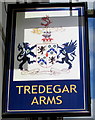
Tredegar Arms name sign, Rogerstone
Hanging from a wall bracket on the corner here. https://www.geograph.org.uk/photo/5758079
Image: © Jaggery
Taken: 1 May 2018
0.06 miles
9
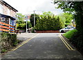
Bethesda Place towards Cefn Road, Rogerstone
Bethesda Place ascends towards the B4591 Cefn Road. The Tredegar Arms pub https://www.geograph.org.uk/photo/5758079 is on the left.
Image: © Jaggery
Taken: 1 May 2018
0.06 miles
10
East side of the Tredegar Arms, Rogerstone
The Bethesda Place side of the pub on the corner of Cefn Road. See https://www.geograph.org.uk/photo/5758079 for a corner view.
Image: © Jaggery
Taken: 1 May 2018
0.06 miles