IMAGES TAKEN NEAR TO
Cefn Road, NEWPORT, NP10 9AQ
Introduction
This page details the photographs taken nearby to Cefn Road, NP10 9AQ by members of the Geograph project.
The Geograph project started in 2005 with the aim of publishing, organising and preserving representative images for every square kilometre of Great Britain, Ireland and the Isle of Man.

There are currently over 7.5m images from over14,400 individuals and you can help contribute to the project by visiting https://www.geograph.org.uk
Image Map
Images are licensed for reuse under creativecommons.org/licenses/by-sa/2.0
Notes
- Clicking on the map will re-center to the selected point.
- The higher the marker number, the further away the image location is from the centre of the postcode.
Image Listing (69 Images Found)
Images are licensed for reuse under creativecommons.org/licenses/by-sa/2.0
Image
Details
Distance
1
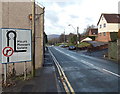
No right turn ahead on Cefn Road, Rogerstone, Newport
The sign informs drivers wishing to enter the estate that turning right into Ruskin Avenue ahead is prohibited. Instead, a left turn must be used after going around the roundabout beyond the junction.
Image: © Jaggery
Taken: 23 Jan 2014
0.00 miles
2
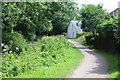
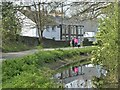
Canal side house, Monmouthshire & Brecon Canal, Cefn
House next to the former towpath, now part of the Sirhowy Valley Walk and National cycle route 47. The disused canal, obscured by vegetation, is to the right.
Image: © M J Roscoe
Taken: 10 Jul 2017
0.01 miles
3
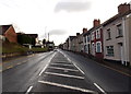
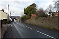
Cefn Road ESE of Ruskin Avenue, Rogerstone, Newport
This is the B4591.
Image: © Jaggery
Taken: 23 Jan 2014
0.02 miles
4
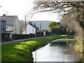
Monmouthshire & Brecon Canal (Crumlin arm)
For a short distance the Crumlin arm of the Monmouthshire and Brecon Canal, the Sirhowy Valley Walk and National Cycle Route 47 run alongside Cefn Road the B4579 at Rogerstone.
Image: © Robin Drayton
Taken: 1 Feb 2008
0.02 miles
5
Taking a dog for a walk along the towpath
This is the Crumlin branch of the Monmouthshire and Brecon Canal at Rogerstone.
Image: © Robin Drayton
Taken: 22 Apr 2023
0.02 miles
6
Cefn Road, Rogerstone, Newport
Looking west between the Rising Sun http://www.geograph.org.uk/photo/3826479 behind the camera and the Ruskin Avenue junction area. The perimeter wall of the disused Crumlin Arm of the Monmouthshire & Brecon Canal http://www.geograph.org.uk/photo/3829851 is on the right.
Image: © Jaggery
Taken: 23 Jan 2014
0.03 miles
7
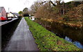
Canal, path and road, Rogerstone, Newport
For about 100 metres, near the Rising Sun, http://www.geograph.org.uk/photo/3826479 the course of the disused Crumlin Arm of the Monmouthshire & Brecon Canal is alongside the B4591 Cefn Road. The former canal towpath is now a public footpath and cycleway.
Image: © Jaggery
Taken: 23 Jan 2014
0.06 miles
8
![Monmouthshire & Brecon Canal [7]](https://s0.geograph.org.uk/geophotos/01/81/77/1817708_9b6c2bc9_120x120.jpg)
Monmouthshire & Brecon Canal [7]
The canal heads towards the top of Fourteen Locks.
Image: © Michael Dibb
Taken: 10 Mar 2010
0.08 miles
9
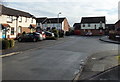
SE edge of Squires Gate, Rogerstone, Newport
Viewed from the corner of Squires Close. http://www.geograph.org.uk/photo/3908856
Squires Gate in an area of modern houses on the east side of Ruskin Avenue.
Image: © Jaggery
Taken: 23 Jan 2014
0.08 miles
10
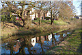
Canal reflections, Rogerstone, Newport
This is a stretch of the Crumlin branch of the Monmouthshire and Brecon Canal to the west of Fourteen Locks https://www.geograph.org.uk/photo/6078609 .
The following shared description is provided by David Dixon.
Image: © Robin Drayton
Taken: 27 Feb 2019
0.09 miles