IMAGES TAKEN NEAR TO
Church Lane, NEWPORT, NP10 8TU
Introduction
This page details the photographs taken nearby to Church Lane, NP10 8TU by members of the Geograph project.
The Geograph project started in 2005 with the aim of publishing, organising and preserving representative images for every square kilometre of Great Britain, Ireland and the Isle of Man.

There are currently over 7.5m images from over14,400 individuals and you can help contribute to the project by visiting https://www.geograph.org.uk
Image Map
Images are licensed for reuse under creativecommons.org/licenses/by-sa/2.0
Notes
- Clicking on the map will re-center to the selected point.
- The higher the marker number, the further away the image location is from the centre of the postcode.
Image Listing (55 Images Found)
Images are licensed for reuse under creativecommons.org/licenses/by-sa/2.0
Image
Details
Distance
1
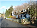
The Old Smithy,Coedkernew
5-bedroom detached house on the east side of Church Lane.
Image: © Jaggery
Taken: 8 Jan 2011
0.03 miles
3
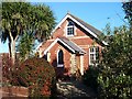
Church House, Coedkernew
This is probably the mission room and Sunday school that is mentioned in Kelly's Directory of 1901. http://freepages.genealogy.rootsweb.com/~familyalbum/kernew.htm
Image: © Robin Drayton
Taken: 23 Nov 2007
0.03 miles
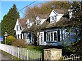
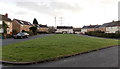
4
Church Crescent, Coedkernew
Houses on the north side of Church Crescent, viewed from the corner of Church Lane.
Image: © Jaggery
Taken: 8 Jan 2011
0.04 miles
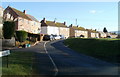
5
Central section of Church Crescent, Coedkernew
Viewed from the corner of Church Lane.
Image: © Jaggery
Taken: 8 Jan 2011
0.04 miles
6
SE end of Church Crescent, Coedkernew
Viewed across a grassy semicircle from the edge of Church Lane.
Image: © Jaggery
Taken: 21 Dec 2012
0.05 miles
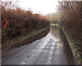
7

Shallow ribbons of water lining Church Lane, Coedkernew
There is a larger volume of standing water http://www.geograph.org.uk/photo/3333015 on Church Lane around the bend ahead.
Image: © Jaggery
Taken: 21 Dec 2012
0.06 miles
8
Flooded Church Lane viewed from the south, Coedkernew
http://www.geograph.org.uk/photo/3333015 to a view from the other side.
Image: © Jaggery
Taken: 21 Dec 2012
0.06 miles
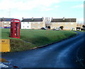
9
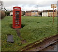
Red phonebox, Coedkernew
Located at the SE junction of Church Crescent and Church Lane.
Image: © Jaggery
Taken: 21 Dec 2012
0.06 miles
10
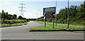
Heading south from A48 , Coedkernew
Dual carriageway heading south from the A48 at Blacksmiths Way roundabout.
Image: © Jaggery
Taken: 9 Sep 2009
0.07 miles