IMAGES TAKEN NEAR TO
Church Road, NEWPORT, NP10 8SN
Introduction
This page details the photographs taken nearby to Church Road, NP10 8SN by members of the Geograph project.
The Geograph project started in 2005 with the aim of publishing, organising and preserving representative images for every square kilometre of Great Britain, Ireland and the Isle of Man.

There are currently over 7.5m images from over14,400 individuals and you can help contribute to the project by visiting https://www.geograph.org.uk
Image Map
Images are licensed for reuse under creativecommons.org/licenses/by-sa/2.0
Notes
- Clicking on the map will re-center to the selected point.
- The higher the marker number, the further away the image location is from the centre of the postcode.
Image Listing (71 Images Found)
Images are licensed for reuse under creativecommons.org/licenses/by-sa/2.0
Image
Details
Distance
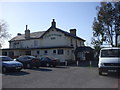
3
Telephone box and friends, at road junction
Nice little assemblage of phone box, letter box, bus shelter, litter bin, no waiting sign...and a motorbike to finish the scene!
Image: © Ruth Sharville
Taken: 22 May 2007
0.04 miles
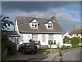
4
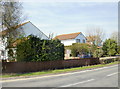
Church Road houses, St Brides
Houses on the east side of Church Road, opposite the Church House Inn.http://www.geograph.org.uk/photo/1859836
Image: © Jaggery
Taken: 22 Apr 2010
0.04 miles
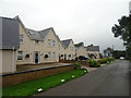
5
Bridesvale Gardens, St Brides
Houses located near the corner of Church Road and the B4239.
Image: © Jaggery
Taken: 22 Apr 2010
0.04 miles
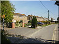
6
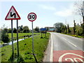
Welcome to St Brides
The B4239 reaches the eastern edge of St Brides. The sign shows St Brides, not St Brides Wentlooge, the name shown on maps to distinguish it from other St Brides.
Another sign emphasises the point that, though the roads locally are flat, they are not always straight.
Image: © Jaggery
Taken: 22 Apr 2010
0.04 miles
7
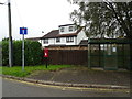
House on Church Road, St Brides Wentlooge
Showing position of Postbox No. NP10 148.
See Image] for postbox.
Image: © JThomas
Taken: 15 Oct 2019
0.04 miles
8
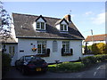
Rehoboth Cottage, St Brides Wentlooge
The building was formerly a chapel, and shares its name with a number of other chapels. The name is taken from an incident recorded in Genesis ch. 26. Isaac had dug a number of wells for his flocks, and each time found his ownership disputed by other shepherds. Finally he dug one with no such challenge occurring, and gave it the name Rehoboth, which means Room, saying, "Now the Lord has made room for us, and we shall be fruitful."
Image: © John Lord
Taken: 20 Apr 2010
0.05 miles
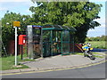
9
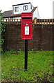
Elizabeth II postbox on Church Road, St Brides Wentlooge
Postbox No. NP10 148.
See Image] for context.
Image: © JThomas
Taken: 15 Oct 2019
0.05 miles
10
Rehoboth Cottage, St Brides Wentlooge
Built in 1828 and formerly Rehoboth Baptist Chapel. Memorials in the graveyard can be seen in the right.
Image: © Robin Drayton
Taken: 9 Nov 2007
0.05 miles