IMAGES TAKEN NEAR TO
St. Brides Wentlooge, NEWPORT, NP10 8SF
Introduction
This page details the photographs taken nearby to NP10 8SF by members of the Geograph project.
The Geograph project started in 2005 with the aim of publishing, organising and preserving representative images for every square kilometre of Great Britain, Ireland and the Isle of Man.

There are currently over 7.5m images from over14,400 individuals and you can help contribute to the project by visiting https://www.geograph.org.uk
Image Map
Images are licensed for reuse under creativecommons.org/licenses/by-sa/2.0
Notes
- Clicking on the map will re-center to the selected point.
- The higher the marker number, the further away the image location is from the centre of the postcode.
Image Listing (15 Images Found)
Images are licensed for reuse under creativecommons.org/licenses/by-sa/2.0
Image
Details
Distance
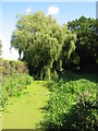
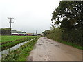
2
A Z-bend in the reen beside Lighthouse Rd
Image: © John Lord
Taken: 20 Apr 2010
0.08 miles
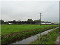
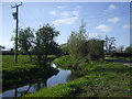
4
Sealand Reen by Lighthouse Road
Drain by B4239, Gwent Levels.
Image: © M J Roscoe
Taken: 3 Apr 2021
0.09 miles
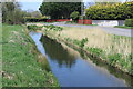
6
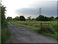
Pont Estyll Lane, Wentlooge Level
On some maps, this road would appear to give a short cut across the Wentlooge Level to the A48 west of Newport. This is not so as can be seen here http://www.geograph.org.uk/photo/376563 .
Image: © Robin Drayton
Taken: 30 Jun 2009
0.15 miles