IMAGES TAKEN NEAR TO
Pencarn Way, NEWPORT, NP10 8SB
Introduction
This page details the photographs taken nearby to Pencarn Way, NP10 8SB by members of the Geograph project.
The Geograph project started in 2005 with the aim of publishing, organising and preserving representative images for every square kilometre of Great Britain, Ireland and the Isle of Man.

There are currently over 7.5m images from over14,400 individuals and you can help contribute to the project by visiting https://www.geograph.org.uk
Image Map
Images are licensed for reuse under creativecommons.org/licenses/by-sa/2.0
Notes
- Clicking on the map will re-center to the selected point.
- The higher the marker number, the further away the image location is from the centre of the postcode.
Image Listing (139 Images Found)
Images are licensed for reuse under creativecommons.org/licenses/by-sa/2.0
Image
Details
Distance
1
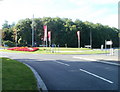
Pencarn Way golfing roundabout, Coedkernew
The roundabout has a golfing theme, with the 2010 Ryder Cup beginning at the Celtic Manor on the east side of the city of Newport on October 1st. Behind the white arrows on a black background sign is a shallow sand-filled bunker, with another one nearby. In the middle of the roundabout are topiary golf figures.
Image: © Jaggery
Taken: 25 Sep 2010
0.09 miles
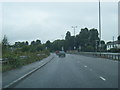
2
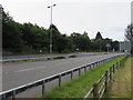
Dual carriageway section of the A48, Coedkernew
Before the opening of the M4 motorway, the A48 was the major route from Newport to Cardiff.
Image: © Jaggery
Taken: 21 Jul 2016
0.11 miles
3
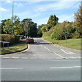
Western section of Pencarn Lane, Coedkernew
Pencarn Lane heads away from the western side of Imperial Way. The eastern section of the lane http://www.geograph.org.uk/photo/2082197 reaches Imperial Way 30 metres south of this point.
Image: © Jaggery
Taken: 25 Sep 2010
0.11 miles
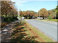
4
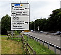
Directions sign facing northbound traffic on the A48, Coedkernew
The path behind the sign leads to a Holiday Inn Express.
Image: © Jaggery
Taken: 21 Jul 2016
0.12 miles
6
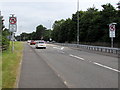
No U turns for two-thirds of a mile on the A48, Coedkernew
Before the opening of the M4 motorway, the major route from Newport to Cardiff was the A48.
Image: © Jaggery
Taken: 21 Jul 2016
0.12 miles
7
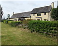
Dragonfly country pub, Coedkernew
The A48 side of the Dragonfly at Lakeside Drive, Coedkernew.
Image: © Jaggery
Taken: 21 Jul 2016
0.12 miles
8
Ryder Cup 2010 park and ride notices, Imperial Way, Coedkernew
Late September 2010 : notices on Imperial Way point in the direction of park and ride facilities for those attending the 2010 Ryder Cup, which begins at Celtic Manor on the eastern side of the city of Newport on October 1, 2010.
Image: © Jaggery
Taken: 25 Sep 2010
0.13 miles
9
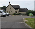
North side of the Dragonfly country pub, Coedkernew
This side of the Dragonfly faces a Holiday Inn Express hotel. http://www.geograph.org.uk/photo/5103633
The yellow marked parking spaces are reserved for the vehicles of Blue Badge holders.
Image: © Jaggery
Taken: 21 Jul 2016
0.14 miles
10
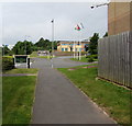
Path from the A48 to a pub and a hotel, Coedkernew, Newport
Turn left ahead for the Dragonfly country pub http://www.geograph.org.uk/photo/5103770 or right for the Holiday Inn Express. http://www.geograph.org.uk/photo/5103633
Image: © Jaggery
Taken: 21 Jul 2016
0.14 miles