IMAGES TAKEN NEAR TO
Springfield Road, NEWPORT, NP10 8RN
Introduction
This page details the photographs taken nearby to Springfield Road, NP10 8RN by members of the Geograph project.
The Geograph project started in 2005 with the aim of publishing, organising and preserving representative images for every square kilometre of Great Britain, Ireland and the Isle of Man.

There are currently over 7.5m images from over14,400 individuals and you can help contribute to the project by visiting https://www.geograph.org.uk
Image Map
Images are licensed for reuse under creativecommons.org/licenses/by-sa/2.0
Notes
- Clicking on the map will re-center to the selected point.
- The higher the marker number, the further away the image location is from the centre of the postcode.
Image Listing (107 Images Found)
Images are licensed for reuse under creativecommons.org/licenses/by-sa/2.0
Image
Details
Distance
1
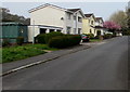
Springfield Road houses, Rhiwderin
The green cabinet is an electricity substation. https://www.geograph.org.uk/photo/6123198
Image: © Jaggery
Taken: 17 Apr 2019
0.01 miles
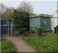
2
Yellow grit/salt box, Springfield Road, Rhiwderin
Image: © Jaggery
Taken: 17 Apr 2019
0.02 miles
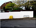
3
Springfield Road electricity substation, Rhiwderin
The cabinet is a Western Power Distribution electricity substation. Its identifier is S/S 531189.
Image: © Jaggery
Taken: 17 Apr 2019
0.02 miles
4
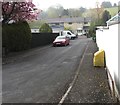
South along Springfield Road, Rhiwderin
Towards Springfield Close.
Image: © Jaggery
Taken: 17 Apr 2019
0.02 miles
5
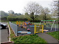
Colourful playground in Rhiwderin
Set back from the south side of Springfield Road.
Image: © Jaggery
Taken: 17 Apr 2019
0.03 miles
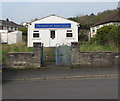
6

Vinyasa Yoga banner, Rhiwderin
On the village hall perimeter wall. https://www.geograph.org.uk/photo/6123179
Image: © Jaggery
Taken: 17 Apr 2019
0.03 miles
7
Rhiwderin Village Hall
Single-storey building on the west side of Pentre Tai Road.
In April 2019 a Vinyasa Yoga banner https://www.geograph.org.uk/photo/6123182 is on the fence on the left.
Image: © Jaggery
Taken: 17 Apr 2019
0.04 miles
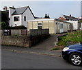
8
Rhiwderin Free Presbyterian Church
On the west side of Pentre Tai Road.
In April 2019 this is one of two places of worship in Rhiwderin.
The other one is Tabernacle Congregational Chapel. https://www.geograph.org.uk/photo/6123027
Image: © Jaggery
Taken: 17 Apr 2019
0.04 miles
9

BT phonebox on a Rhiwderin corner
On the corner of Pentre Tai Road and Springfield Road on the north side of Rhiwderin Community Centre.
Image: © Jaggery
Taken: 17 Apr 2019
0.04 miles
10
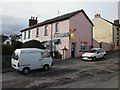
Rhiwderin Post Office
Post office and newsagents at the southern end of Tredegar Street.
Image: © Jaggery
Taken: 1 Apr 2010
0.04 miles