IMAGES TAKEN NEAR TO
Pentre Tai Road, NEWPORT, NP10 8RL
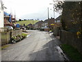
Introduction
This page details the photographs taken nearby to Pentre Tai Road, NP10 8RL by members of the Geograph project.
The Geograph project started in 2005 with the aim of publishing, organising and preserving representative images for every square kilometre of Great Britain, Ireland and the Isle of Man.

There are currently over 7.5m images from over14,400 individuals and you can help contribute to the project by visiting https://www.geograph.org.uk
Image Map
Images are licensed for reuse under creativecommons.org/licenses/by-sa/2.0
Notes
- Clicking on the map will re-center to the selected point.
- The higher the marker number, the further away the image location is from the centre of the postcode.
Image Listing (104 Images Found)
Images are licensed for reuse under creativecommons.org/licenses/by-sa/2.0
Image
Details
Distance
1
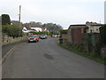
Pentre-Tai Road, Rhiwderin heads towards Caerphilly Road
Behind the camera, Pentrai-Tai Road has widened from a single track road. http://www.geograph.org.uk/photo/1787390
Image: © Jaggery
Taken: 1 Apr 2010
0.03 miles
2

Pentre Tai Road, Rhiwderin
Along Pentre Tai Road from the edge of the village towards its centre.
Image: © Jaggery
Taken: 17 Apr 2019
0.04 miles
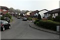
3
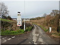
Single track road ahead, Rhiwderin
Heading away from Rhiwderin towards Pentre Tai farm, Pentre Tai Road narrows from a suburban road http://www.geograph.org.uk/photo/1787395 to a single track country road.
Image: © Jaggery
Taken: 1 Apr 2010
0.04 miles
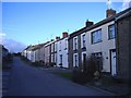
4
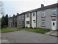
Houses at the northern end of Tredegar Street, Rhiwderin
At the dead end of this https://www.geograph.org.uk/photo/6128731 street.
Image: © Jaggery
Taken: 17 Apr 2019
0.05 miles
5
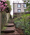
Steps ascending from the northern end of Tredegar Street, Rhiwderin
Part of a public footpath to the northern end of Tabernacle Drive.
Image: © Jaggery
Taken: 17 Apr 2019
0.05 miles
6
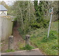
Path beyond the northern end of Tredegar Street, Rhiwderin
Public footpath towards Pentre Tai Road.
Image: © Jaggery
Taken: 17 Apr 2019
0.05 miles
7
North along Pentre Tai Road, Rhiwderin
From the corner of Springfield Road.
Image: © Jaggery
Taken: 17 Apr 2019
0.06 miles
9
Northeast end of Springfield Lane, Rhiwderin
Viewed from the corner of Springfield Road.
Image: © Jaggery
Taken: 17 Apr 2019
0.06 miles
10
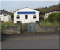
Rhiwderin Free Presbyterian Church
On the west side of Pentre Tai Road.
In April 2019 this is one of two places of worship in Rhiwderin.
The other one is Tabernacle Congregational Chapel. https://www.geograph.org.uk/photo/6123027
Image: © Jaggery
Taken: 17 Apr 2019
0.06 miles