IMAGES TAKEN NEAR TO
Churchmead, NEWPORT, NP10 8NA
Introduction
This page details the photographs taken nearby to Churchmead, NP10 8NA by members of the Geograph project.
The Geograph project started in 2005 with the aim of publishing, organising and preserving representative images for every square kilometre of Great Britain, Ireland and the Isle of Man.

There are currently over 7.5m images from over14,400 individuals and you can help contribute to the project by visiting https://www.geograph.org.uk
Image Map
Images are licensed for reuse under creativecommons.org/licenses/by-sa/2.0
Notes
- Clicking on the map will re-center to the selected point.
- The higher the marker number, the further away the image location is from the centre of the postcode.
Image Listing (125 Images Found)
Images are licensed for reuse under creativecommons.org/licenses/by-sa/2.0
Image
Details
Distance
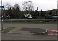
1
The A468 at Bassaleg
The A468 approaching a roundabout on a junction with the A467 at Bassaleg.
Image: © Philip Halling
Taken: 26 Jun 2010
0.03 miles
2
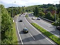
A467 at Bassaleg
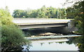
The southern end of the A467 where it crosses the River Ebbw.
Image: © Robin Drayton
Taken: 13 Aug 2007
0.04 miles
4
Ebbw River weir, Bassaleg
The view southeast from the corner of Forge Mews and Caerphilly Road. Beyond the weir, the Ebbw flows under the A467.
Image: © Jaggery
Taken: 19 Sep 2009
0.05 miles
5
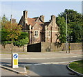
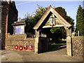
Glebe House, Forge Road, Newport
Located opposite Vicarage Close. A glebe house was one built on land attached to a parish church, in this case, St Basil's.http://www.geograph.org.uk/photo/1038070
Forge Road was formerly Forge Lane. I don't know exactly when it was renamed, but it was still Forge Lane in the 1960s. The name Forge Lane survives for the northern end of the old lane, about 100 metres in length, which is a few metres west of the course of Forge Road (A4072).
Image: © Jaggery
Taken: 19 Sep 2009
0.06 miles
6
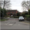
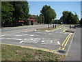
Churchmead, Bassaleg
Northern end of a cul-de-sac near St Basil's church.
Image: © Jaggery
Taken: 19 Mar 2019
0.06 miles
7
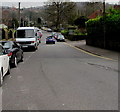
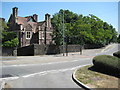
Unclassified part of Caerphilly Road, Bassaleg
The A468 Caerphilly Road is behind the camera. Caerphilly Road ahead is not a through route for motor vehicles.
Image: © Jaggery
Taken: 19 Mar 2019
0.07 miles
8
Cycle route 47 direction sign, Viaduct Way, Bassaleg
The white arrow on the sign points towards National Cycle Network Route 47,
a mainly inland route from Newport to Fishguard via Neath and Carmarthen.
Image: © Jaggery
Taken: 19 Mar 2019
0.08 miles
9
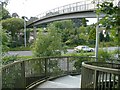
Footbridge over the A467 at Bassaleg
With spiral steps at each side, this is the viewpoint for Image
Image: © Robin Drayton
Taken: 13 Aug 2007
0.08 miles