IMAGES TAKEN NEAR TO
Station Approach, NEWPORT, NP10 8LD
Introduction
This page details the photographs taken nearby to Station Approach, NP10 8LD by members of the Geograph project.
The Geograph project started in 2005 with the aim of publishing, organising and preserving representative images for every square kilometre of Great Britain, Ireland and the Isle of Man.

There are currently over 7.5m images from over14,400 individuals and you can help contribute to the project by visiting https://www.geograph.org.uk
Image Map
Images are licensed for reuse under creativecommons.org/licenses/by-sa/2.0
Notes
- Clicking on the map will re-center to the selected point.
- The higher the marker number, the further away the image location is from the centre of the postcode.
Image Listing (172 Images Found)
Images are licensed for reuse under creativecommons.org/licenses/by-sa/2.0
Image
Details
Distance
1
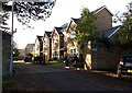
St Basil's Rise, Bassaleg, Newport
Viewed from Station Approach opposite Junction 28 restaurant.
St Basil's Rise is a cul-de-sac adjacent to the NW side of St Basil's Church.
Image: © Jaggery
Taken: 14 Nov 2013
0.02 miles
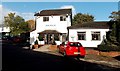
2

Old railway notice on the side wall of Junction 28 restaurant, Bassaleg, Newport
The restaurant http://www.geograph.org.uk/photo/3744673 occupies what used to be the Machen-bound or up platform of Bassaleg's Brecon and Merthyr railway station. The lack of any punctuation is interesting. Perhaps this was how railway notices of the period (possibly late Victorian or Edwardian) were written in this area.
There is no indication whether or not this notice was originally on this site.
Image: © Jaggery
Taken: 14 Nov 2013
0.03 miles
3
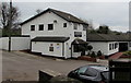
Junction 28 restaurant, Station Approach, Bassaleg
The restaurant is in a converted former building on what used to be the Machen-bound or up platform of Bassaleg's Brecon and Merthyr railway station. Passenger services at the station ended in 1962. The restaurant's name refers to the nearby M4 motorway junction.
Image: © Jaggery
Taken: 19 Mar 2019
0.03 miles
4
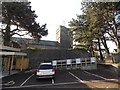
Priority parking for church hall users, Bassaleg
The small parking area is alongside St Basil's church hall. http://www.geograph.org.uk/photo/3744428
St Basil's Church is in the background.
Image: © Jaggery
Taken: 14 Nov 2013
0.03 miles
5
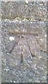
Ordnance Survey Cut Mark
This OS cut mark can be found on the west face of St Basil's Church. It marks a point 33.321m above mean sea level.
Image: © Adrian Dust
Taken: 28 Feb 2016
0.03 miles
6
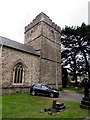
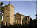
Tower of St Basil's Church, Bassaleg
At the NW corner of this https://www.geograph.org.uk/photo/6150210 church in the Church in Wales Diocese of Monmouth.
Image: © Jaggery
Taken: 19 Mar 2019
0.03 miles
7
Entrance to Junction 28 restaurant in Bassaleg, Newport
Viewed across Station Approach. The restaurant is built on what used to be the Machen-bound or up platform of Bassaleg's Brecon and Merthyr railway station.
Image: © Jaggery
Taken: 14 Nov 2013
0.03 miles
8
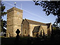
Parish church of St Basil the Great, Bassaleg
Image: © John Lord
Taken: 12 Jan 2012
0.03 miles
9
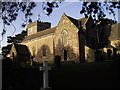
Parish church of St Basil the Great, Bassaleg
Image: © John Lord
Taken: 12 Jan 2012
0.03 miles
10
Parish church of St Basil the Great, Bassaleg
Image: © John Lord
Taken: 12 Jan 2012
0.03 miles