IMAGES TAKEN NEAR TO
Sunnybank, NEWPORT, NP10 8JP
Introduction
This page details the photographs taken nearby to Sunnybank, NP10 8JP by members of the Geograph project.
The Geograph project started in 2005 with the aim of publishing, organising and preserving representative images for every square kilometre of Great Britain, Ireland and the Isle of Man.

There are currently over 7.5m images from over14,400 individuals and you can help contribute to the project by visiting https://www.geograph.org.uk
Image Map
Images are licensed for reuse under creativecommons.org/licenses/by-sa/2.0
Notes
- Clicking on the map will re-center to the selected point.
- The higher the marker number, the further away the image location is from the centre of the postcode.
Image Listing (62 Images Found)
Images are licensed for reuse under creativecommons.org/licenses/by-sa/2.0
Image
Details
Distance
1
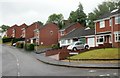
South side of Parkwood Drive, Newport
Houses on the south side of Parkwood Drive, Pentrepoeth, Bassaleg, viewed from the corner of Cwm Cwddy Drive.
Image: © Jaggery
Taken: 29 May 2010
0.10 miles
2
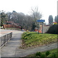
NW boundary of Bassaleg
Viewed from Rhiwderin, near the Friendly Fox pub. http://www.geograph.org.uk/photo/1780840
The road on the left is Caerphilly Road (A468).
Image: © Jaggery
Taken: 5 Mar 2011
0.11 miles
3
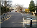
Caerphilly Close, Rhiwderin
Viewed from the Caerphilly Road (A468) end. The Friendly Fox pub is on the right. http://www.geograph.org.uk/photo/1780840
Image: © Jaggery
Taken: 5 Mar 2011
0.12 miles
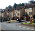
4
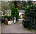
Early 19th century houses in Bassaleg
Set back from the west side of the A468 Caerphilly Road. The tablet on the wall shows the year 1815. https://www.geograph.org.uk/photo/6113736
Image: © Jaggery
Taken: 20 Mar 2019
0.14 miles
5
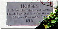
Tablet dated 1815, Bassaleg
The stone tablet on the wall here https://www.geograph.org.uk/photo/6113731 records
HOUSES Built by the Inhabitants of the Hamlet of Duffrin for the use Of their Poor in the Year 1815.
Image: © Jaggery
Taken: 20 Mar 2019
0.14 miles
6
Ffos-y-fran houses, Bassaleg
Ffos-y-fran is a cul-de-sac of 57 houses connecting with Caerphilly Road, Bassaleg.
Ffos-y-fran is Welsh for Crow's Ditch. Ffos is one of a small number of words in Welsh derived from Latin, in this case, fossa, a ditch. Fran is a mutated form of bran, a crow. In Welsh, the correct spellings are brân and frân. The 'hat' (circumflex accent) over the a distinguishes brân (crow) from bran (bran).
Image: © Jaggery
Taken: 5 Mar 2011
0.15 miles
7
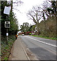
Your Speed indicator, Caerphilly Road, Bassaleg
Currently off, the display alongside the A468 turns on to show the speed in green
if an approaching vehicle is within the speed limit, or in red if over the speed limit.
Image: © Jaggery
Taken: 20 Mar 2019
0.15 miles
8
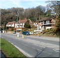
Caerphilly Road houses near Ffos-y-fran, Bassaleg
The houses are on the north side of Caerphilly Road, viewed from near the Ffos-y-fran turning. http://www.geograph.org.uk/photo/2771253
Image: © Jaggery
Taken: 5 Mar 2011
0.16 miles
9
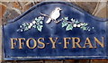
Ffos-y-fran name sign, Bassaleg
Located at the corner of Ffos-y-fran http://www.geograph.org.uk/photo/2771253 and Caerphilly Road. Ffos-y-fran is Welsh for crow's ditch, but the bird represented is unlike any crow to be seen hereabouts!
Image: © Jaggery
Taken: 5 Mar 2011
0.16 miles
10
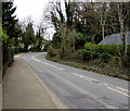
Bend in the A468 Caerphilly Road, Basseleg
Double white lines ahead indicate no overtaking. This way for Rhiwderin and Caerphilly.
Image: © Jaggery
Taken: 20 Mar 2019
0.16 miles