IMAGES TAKEN NEAR TO
Cwm-Cwddy Drive, NEWPORT, NP10 8JA
Introduction
This page details the photographs taken nearby to Cwm-Cwddy Drive, NP10 8JA by members of the Geograph project.
The Geograph project started in 2005 with the aim of publishing, organising and preserving representative images for every square kilometre of Great Britain, Ireland and the Isle of Man.

There are currently over 7.5m images from over14,400 individuals and you can help contribute to the project by visiting https://www.geograph.org.uk
Image Map
Images are licensed for reuse under creativecommons.org/licenses/by-sa/2.0
Notes
- Clicking on the map will re-center to the selected point.
- The higher the marker number, the further away the image location is from the centre of the postcode.
Image Listing (5 Images Found)
Images are licensed for reuse under creativecommons.org/licenses/by-sa/2.0
Image
Details
Distance
1
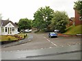
Llwyn Deri Close, Newport
Viewed from Cwm Cwddy Drive, Pentrepoeth, Bassaleg.
Image: © Jaggery
Taken: 29 May 2010
0.05 miles
2
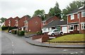
South side of Parkwood Drive, Newport
Houses on the south side of Parkwood Drive, Pentrepoeth, Bassaleg, viewed from the corner of Cwm Cwddy Drive.
Image: © Jaggery
Taken: 29 May 2010
0.07 miles
3
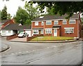
Parkwood Drive, Newport
The western end of Parkwood Drive, Pentrepoeth, Bassaleg, viewed from Cwm Cwddy Drive.
Image: © Jaggery
Taken: 29 May 2010
0.09 miles
4
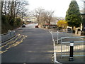
Caerphilly Close, Rhiwderin
Viewed from the Caerphilly Road (A468) end. The Friendly Fox pub is on the right. http://www.geograph.org.uk/photo/1780840
Image: © Jaggery
Taken: 5 Mar 2011
0.21 miles
5
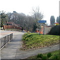
NW boundary of Bassaleg
Viewed from Rhiwderin, near the Friendly Fox pub. http://www.geograph.org.uk/photo/1780840
The road on the left is Caerphilly Road (A468).
Image: © Jaggery
Taken: 5 Mar 2011
0.24 miles