IMAGES TAKEN NEAR TO
Rhyd Y Gwern Lane, NEWPORT, NP10 8GJ
Introduction
This page details the photographs taken nearby to Rhyd Y Gwern Lane, NP10 8GJ by members of the Geograph project.
The Geograph project started in 2005 with the aim of publishing, organising and preserving representative images for every square kilometre of Great Britain, Ireland and the Isle of Man.

There are currently over 7.5m images from over14,400 individuals and you can help contribute to the project by visiting https://www.geograph.org.uk
Image Map
Images are licensed for reuse under creativecommons.org/licenses/by-sa/2.0
Notes
- Clicking on the map will re-center to the selected point.
- The higher the marker number, the further away the image location is from the centre of the postcode.
Image Listing (15 Images Found)
Images are licensed for reuse under creativecommons.org/licenses/by-sa/2.0
Image
Details
Distance
1
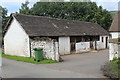
Stables, Rhyd-y-Gwern Farm
Whitewashed stone stables in historic farmyard.
Image: © M J Roscoe
Taken: 17 Aug 2019
0.01 miles
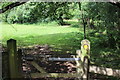
3
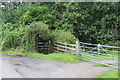
Gated footpath from Rhyd-y-Gwern Farm
Public footpath, part of Rhymney Valley Ridgeway Walk, into small wood.
Image: © M J Roscoe
Taken: 17 Aug 2019
0.03 miles
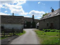
4
Grassy track to Rhyd-y-Gwern Farm
The track carries a long distance footpath, and is seen from above the next gate in Image
Image: © M J Roscoe
Taken: 17 Aug 2019
0.04 miles
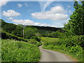
6
Grassy track near Rhyd-y-Gwern Farm
The track carries a long distance public footpath which veers to the right after the far gate Image
Image: © M J Roscoe
Taken: 17 Aug 2019
0.08 miles
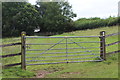
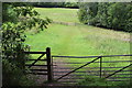
8
Field footpath
Public footpath along edge of field.
Image: © M J Roscoe
Taken: 17 Aug 2019
0.15 miles
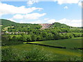
9
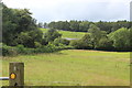
Fields either side of Rhyd-y-Gwern Lane
The hedgerow on the left is on the nearside of the lane; the roof of the building (centre) is at Fferm Pont Carreg on the far side of the lane. The woodland on the skyline is part of Coed Cefn-pwll-du.
Image: © M J Roscoe
Taken: 17 Aug 2019
0.17 miles
10
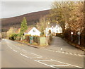
Junction of A468 and Royal Oak, Chatham, Machen
On the right, the residential road Royal Oak heads away from the A468 into Chatham, an area in the SE of the village of Machen.
Image: © Jaggery
Taken: 14 Feb 2011
0.22 miles