IMAGES TAKEN NEAR TO
Lower Machen, NEWPORT, NP10 8GG
Introduction
This page details the photographs taken nearby to NP10 8GG by members of the Geograph project.
The Geograph project started in 2005 with the aim of publishing, organising and preserving representative images for every square kilometre of Great Britain, Ireland and the Isle of Man.

There are currently over 7.5m images from over14,400 individuals and you can help contribute to the project by visiting https://www.geograph.org.uk
Image Map
Images are licensed for reuse under creativecommons.org/licenses/by-sa/2.0
Notes
- Clicking on the map will re-center to the selected point.
- The higher the marker number, the further away the image location is from the centre of the postcode.
Image Listing (27 Images Found)
Images are licensed for reuse under creativecommons.org/licenses/by-sa/2.0
Image
Details
Distance
1
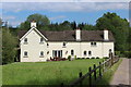
West Lodge, Rhymney Valley Ridgeway Walk
The woodland behind the house is part of Coed Craig Ruperra, and the lodge was presumably once associated with Ruperra Castle.
Image: © M J Roscoe
Taken: 21 May 2019
0.01 miles
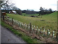
2
Part of Coed Craig Ruperra woodland
Trails and paths criss-cross the wooded hill and a gradual process of restoration is underway on the hill to change parts of it from woodland into open grassland.
Image: © Jeremy Bolwell
Taken: 4 Mar 2012
0.03 miles
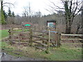
3
Western entrance to Coed Craig Ruperra
Gateway to the West Lodge Path, a bridleway, into the Planted Ancient Woodland Site, now a historic park
Image: © M J Roscoe
Taken: 21 May 2019
0.03 miles
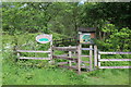
4
Path by walled grounds of Ruperra Castle
The footpath, part of the Rhymney River Circular Walk, runs up alongside the wall (left), and joins the Rhymney Valley Ridgeway Walk just to the right of the metal fence.
Image: © M J Roscoe
Taken: 21 May 2019
0.15 miles
5
Feature within the old parkland of Ruperra Castle
The circular mound with trees was once a feature within the parkland of the Ruperra Castle estate I assume.
Image: © Jeremy Bolwell
Taken: 4 Mar 2012
0.18 miles
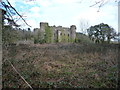
6
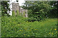
Ruperra Castle
Ruperra Castle was built in 1626 by Sir Thomas Morgan. Traditionally the castle has been the home to the heir to the Tredegar estate. During its history the castle has been the victim of two fires, after the first in 1785 it was rebuilt with the gables replaced with the battlements we see today. The second disastrous fire occurred in 1941 when the castle was used to billet the army during the Second World War. In recent years the castle has been owned by a property developer who had plans to redevelop the site, however, this was declined due to the discovery of nesting of Greater and Lesser horseshoe bats. In September 2010, the site was placed on the market for £1.5m. Here the ruin is viewed from the footpath passing to the west.
Image: © Philip Halling
Taken: 14 May 2011
0.20 miles
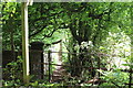
7
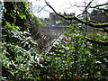
Old glasshouse at the rear of Ruperra Castle
Once carefully tended by a team of gardeners and now a shattered ruin.
Image: © Jeremy Bolwell
Taken: 4 Mar 2012
0.20 miles
8
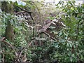
Ruined Glasshouse at Ruperra Castle
Visible through the fence from the immediately adjacent lane, these glasshouses are now almost entirely overgrown.
Image: © Nigel Davies
Taken: 17 Apr 2011
0.20 miles
9
Ruperra Castle ruins from the south
Despite its parlous state today it is still fairly easy to imagine what this fine residence must have looked like in its heyday - which was a pretty long heyday, running from 1626 when it was built until the 1930's, so around 300 years.
A fire in 1941, when the army were tenanted in and around the castle during the early years of World War II, left it as a burned out shell. It had already been vacated by the Morgan family of nearby Tredegar Park fame as the 1930's Depression had left their interests severely weakened and there was no National Trust-like body or local authority interest to take it on for the nation.
Image: © Jeremy Bolwell
Taken: 4 Mar 2012
0.21 miles
10
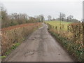
Rhymney Valley Ridgeway Walk
This track is leading east towards Ruperra Castle.
Image: © John Light
Taken: 9 Mar 2012
0.21 miles