IMAGES TAKEN NEAR TO
Schooner Close, NEWPORT, NP10 8EZ
Introduction
This page details the photographs taken nearby to Schooner Close, NP10 8EZ by members of the Geograph project.
The Geograph project started in 2005 with the aim of publishing, organising and preserving representative images for every square kilometre of Great Britain, Ireland and the Isle of Man.

There are currently over 7.5m images from over14,400 individuals and you can help contribute to the project by visiting https://www.geograph.org.uk
Image Map
Images are licensed for reuse under creativecommons.org/licenses/by-sa/2.0
Notes
- Clicking on the map will re-center to the selected point.
- The higher the marker number, the further away the image location is from the centre of the postcode.
Image Listing (118 Images Found)
Images are licensed for reuse under creativecommons.org/licenses/by-sa/2.0
Image
Details
Distance
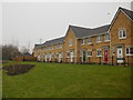
1
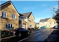
Schooner Avenue houses, Newport
Viewed from Morgan Way, near the junction with Lighthouse Road. The houses were built c2007.
Image: © Jaggery
Taken: 25 Dec 2013
0.03 miles
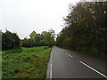
2
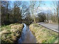
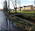
Reen beside Lighthouse Road
The A4239 towards Newport near to the entrance of Duffryn High School.
Image: © Robin Drayton
Taken: 10 Mar 2009
0.05 miles
3
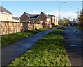
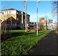
Morgan Way pavement and grass verge, Newport
Looking east towards Lighthouse Road.
Image: © Jaggery
Taken: 10 Nov 2012
0.06 miles
4
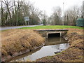
Reen tunnel, Lighthouse Road, Newport
A reen (drainage channel) on the west side of Lighthouse Road, enters a tunnel to pass under Morgan Way.
Image: © Jaggery
Taken: 21 Jan 2010
0.06 miles
5
Schooner Walk, Newport
Houses on Schooner Walk viewed from Lighthouse Road. Access to the houses is from Morgan Way.
Image: © Jaggery
Taken: 21 Jan 2010
0.06 miles
6
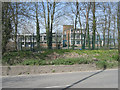
Duffryn High School
Duffryn High School as seen from the B4239.
Image: © Peter Wasp
Taken: 6 Apr 2007
0.06 miles
7
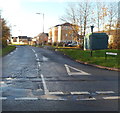
Eastern end of Morgan Way, Newport
Viewed from Lighthouse Road.
Image: © Jaggery
Taken: 10 Nov 2012
0.06 miles
9
Path to the SE corner of Duffryn High School, Newport
The building on the left is Port Royal House, Schooner Walk.
Image: © Jaggery
Taken: 25 Dec 2013
0.06 miles
10
Reen footbridge, Duffryn, Newport
The small bridge gives walkers a short cut from Lighthouse Road to the houses.
The reen is part of an extensive network of channels draining the Wentlooge Level.
Image: © Jaggery
Taken: 25 Dec 2013
0.06 miles