IMAGES TAKEN NEAR TO
Holland Close, NEWPORT, NP10 0AU
Introduction
This page details the photographs taken nearby to Holland Close, NP10 0AU by members of the Geograph project.
The Geograph project started in 2005 with the aim of publishing, organising and preserving representative images for every square kilometre of Great Britain, Ireland and the Isle of Man.

There are currently over 7.5m images from over14,400 individuals and you can help contribute to the project by visiting https://www.geograph.org.uk
Image Map
Images are licensed for reuse under creativecommons.org/licenses/by-sa/2.0
Notes
- Clicking on the map will re-center to the selected point.
- The higher the marker number, the further away the image location is from the centre of the postcode.
Image Listing (108 Images Found)
Images are licensed for reuse under creativecommons.org/licenses/by-sa/2.0
Image
Details
Distance
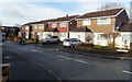
1
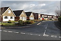
Bentley Close, Rogerstone, Newport
Viewed across Ruskin Avenue.
Image: © Jaggery
Taken: 23 Jan 2014
0.03 miles
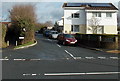
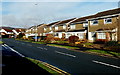
2
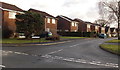
Holland Close, Rogerstone, Newport
Houses on the north side of Holland Close, viewed from Ruskin Avenue.
Image: © Jaggery
Taken: 23 Jan 2014
0.03 miles
3
Kent Close, Rogerstone, Newport
110 metre long cul-de-sac on the SE side of Ruskin Avenue.
Image: © Jaggery
Taken: 23 Jan 2014
0.05 miles
4
Footpath formerly a country road, Rogerstone, Newport
In 2014, vehicular access along Groes Road ends a couple of metres behind the camera at this http://www.geograph.org.uk/photo/3943930 junction. Old maps show that Groes Road used to extend to the B4591 Cefn Road along the route ahead, now blocked off to make it a footpath.
Image: © Jaggery
Taken: 23 Jan 2014
0.06 miles
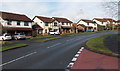
5
Paxton Walk, Rogerstone, Newport
Viewed across Ruskin Avenue.
Image: © Jaggery
Taken: 23 Jan 2014
0.06 miles
6
North side of Sward Close, Rogerstone, Newport
Viewed from the corner of Ruskin Avenue.
Image: © Jaggery
Taken: 23 Jan 2014
0.06 miles
7
Sward Close, Rogerstone, Newport
A short cul-de-sac on the west side of Ruskin Avenue.
Image: © Jaggery
Taken: 23 Jan 2014
0.07 miles
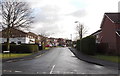
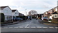
8
Bend in Ruskin Avenue, Rogerstone, Newport
Looking north from the corner of Groes Road. http://www.geograph.org.uk/photo/3943930
Ruskin Avenue is the main road through the Mount Pleasant estate.
Image: © Jaggery
Taken: 23 Jan 2014
0.08 miles
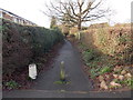
9
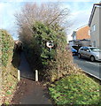
No cars or motorbikes ahead, Groes Road, Rogerstone, Newport
It seems that this narrow path, shown as Groes Road on some maps, is a right of way existing from before the modern houses surrounding it were built. The sign shows no cars or motorbikes, but the function of the concrete posts is unclear. The gap is wide enough for a motorbike to pass through.
The way ahead looks to be too narrow for a car. Paxton Walk is on the right. http://www.geograph.org.uk/photo/3823868
Image: © Jaggery
Taken: 23 Jan 2014
0.08 miles
10
Ruskin Avenue passes Johnston Close, Rogerstone, Newport
Ruskin Avenue, the main road through the Mount Pleasant area of Rogerstone,
passes the left turn for Johnston Close. http://www.geograph.org.uk/photo/3909245
Image: © Jaggery
Taken: 23 Jan 2014
0.08 miles