IMAGES TAKEN NEAR TO
Burford Way, WELLINGBOROUGH, NN8 2JF
Introduction
This page details the photographs taken nearby to Burford Way, NN8 2JF by members of the Geograph project.
The Geograph project started in 2005 with the aim of publishing, organising and preserving representative images for every square kilometre of Great Britain, Ireland and the Isle of Man.

There are currently over 7.5m images from over14,400 individuals and you can help contribute to the project by visiting https://www.geograph.org.uk
Image Map (Loading...)


Getting Data...Please wait
Leaflet Map data © OpenStreetMap
Images are licensed for reuse under creativecommons.org/licenses/by-sa/2.0
Notes
- Clicking on the map will re-center to the selected point.
- The higher the marker number, the further away the image location is from the centre of the postcode.
Image Listing (7 Images Found)
Images are licensed for reuse under creativecommons.org/licenses/by-sa/2.0
Image
Details
Distance
3
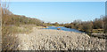
Swanspool Lake
The lampposts, to the left of the lake, follow the route of a path, which can be used by cyclists as well as pedestrians.
Image: © John Baker
Taken: 15 Feb 2019
0.12 miles
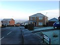
4
Cotswold Drive, Wellingborough
Part of a modern housing estate on the southern outskirts of Wellingborough.
Image: © David Dixon
Taken: 6 Sep 2016
0.14 miles
5
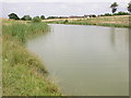
Fishing Lake
No membership required for fishing rights. Council-owned.
Image: © Kokai
Taken: 13 Jul 2005
0.14 miles
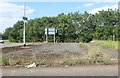
7
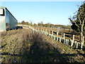
Development site
Viewed from a footpath running between Northampton Road and Moret Avenue. The tuley tubes indicate that a hedge is to be planted here in the future, while the ground beyond looks as if it has been cleared. A wire fence has also been erected round the site.
Image: © John Baker
Taken: 15 Feb 2019
0.21 miles