IMAGES TAKEN NEAR TO
Turnells Mill Lane, WELLINGBOROUGH, NN8 2ED
Introduction
This page details the photographs taken nearby to Turnells Mill Lane, NN8 2ED by members of the Geograph project.
The Geograph project started in 2005 with the aim of publishing, organising and preserving representative images for every square kilometre of Great Britain, Ireland and the Isle of Man.

There are currently over 7.5m images from over14,400 individuals and you can help contribute to the project by visiting https://www.geograph.org.uk
Image Map
Images are licensed for reuse under creativecommons.org/licenses/by-sa/2.0
Notes
- Clicking on the map will re-center to the selected point.
- The higher the marker number, the further away the image location is from the centre of the postcode.
Image Listing (36 Images Found)
Images are licensed for reuse under creativecommons.org/licenses/by-sa/2.0
Image
Details
Distance
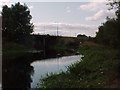
2
A45 Bridge over River Nene at little Irchester
Image: © David Dixon
Taken: 7 Sep 2016
0.06 miles
3
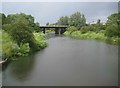
River Nene Navigation: A45 road bridge
This is the view from the footbridge at the Upper Wellingborough Lock. Prior to the construction of the A45 dual carriageway, old large scale Ordnance Survey maps show that the Navigation ran in a straight line from here direct to Image], so a fairly major diversion of its route was necessary to get it to go under the new road more or less perpendicularly, rather than at a narrow angle.
Image: © Nigel Cox
Taken: 16 Jun 2019
0.07 miles
4
Nene Way approaching Upper Wellingborough Lock
Image: © David Dixon
Taken: 7 Sep 2016
0.11 miles
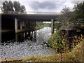
7
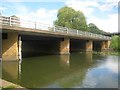
River Nene: Wellingborough Bridge
Wellingborough Bridge carries the A509 road over the River Nene. The arrow indicates the arch through which navigation should pass, while the gauge board to the left does not indicate the water level as such but the available freeboard for navigation above the water. Ie, if the water level in the river rises during a flood event, the board indicates how much height space is left below the bridge arch.
Image: © Nigel Cox
Taken: 16 Jun 2019
0.13 miles
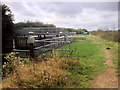
9
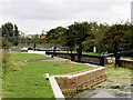
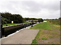
Upper Wellingborough Lock
Lock on the canalised section of the River Nene near Wellingborough.
Image: © David Dixon
Taken: 7 Sep 2016
0.13 miles
10
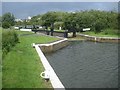
River Nene Navigation: Upper Wellingborough Lock (2)
Please compare with David Dixon's Image] taken in September 2016 from nearly the same viewpoint.
Image: © Nigel Cox
Taken: 16 Jun 2019
0.13 miles