IMAGES TAKEN NEAR TO
Johns Road, NORTHAMPTON, NN7 3PY
Introduction
This page details the photographs taken nearby to Johns Road, NN7 3PY by members of the Geograph project.
The Geograph project started in 2005 with the aim of publishing, organising and preserving representative images for every square kilometre of Great Britain, Ireland and the Isle of Man.

There are currently over 7.5m images from over14,400 individuals and you can help contribute to the project by visiting https://www.geograph.org.uk
Image Map
Images are licensed for reuse under creativecommons.org/licenses/by-sa/2.0
Notes
- Clicking on the map will re-center to the selected point.
- The higher the marker number, the further away the image location is from the centre of the postcode.
Image Listing (9 Images Found)
Images are licensed for reuse under creativecommons.org/licenses/by-sa/2.0
Image
Details
Distance
1
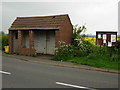
Bus shelter in Bugbrooke
This substantial, but dilapidated, bus shelter stand on the north side of Kislingbury Road, near the junction with Johns Road.
Image: © Stephen McKay
Taken: 14 May 2006
0.15 miles
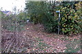
3
Bugbrooke-Johns Road
At the junction with Kislingbury Road.
Image: © Ian Rob
Taken: 27 May 2021
0.16 miles
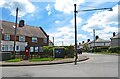
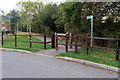
4
Pilgrim's Lane
With a tin giraffe watching the coming and going
Image: © Philip Jeffrey
Taken: 21 Oct 2018
0.17 miles
6
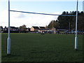
Bugbrooke RUFC
An under the crossbar view of Bugbrooke rugby football club on the morning of an under 16 league fixture, Bugbrooke V Peterborough. Apart from a Peterborough win the highlight of the visit was the not unpleasant smell of bacon rolls being served almost pitch side for the duration of the game from the little lean to (middle right of the photo)
Image: © Michael Trolove
Taken: 7 Nov 2010
0.22 miles
7
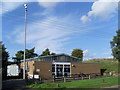
Telephone Exchange, Bugbrooke
Situated in Kislingbury Road, this standard design TE from the late 1960s also serves Harpole, Kislingbury, Rothersthorpe and Upper Heyford nearby, in addition to Bugbrooke. Its postcode is NN7 3QG.
Image: © David Hillas
Taken: 11 Sep 2010
0.23 miles
9
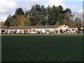
Bugbrooke RUFC
Looking across the rugby pitch to the club house and changing rooms. The Bacon roll dispensary is to the right. Image
Image: © Michael Trolove
Taken: 7 Nov 2010
0.25 miles