IMAGES TAKEN NEAR TO
Olney Road, NORTHAMPTON, NN7 1HL
Introduction
This page details the photographs taken nearby to Olney Road, NN7 1HL by members of the Geograph project.
The Geograph project started in 2005 with the aim of publishing, organising and preserving representative images for every square kilometre of Great Britain, Ireland and the Isle of Man.

There are currently over 7.5m images from over14,400 individuals and you can help contribute to the project by visiting https://www.geograph.org.uk
Image Map
Images are licensed for reuse under creativecommons.org/licenses/by-sa/2.0
Notes
- Clicking on the map will re-center to the selected point.
- The higher the marker number, the further away the image location is from the centre of the postcode.
Image Listing (8 Images Found)
Images are licensed for reuse under creativecommons.org/licenses/by-sa/2.0
Image
Details
Distance
1
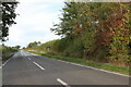
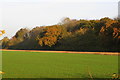
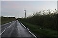
The Pastures Farm near Yardley Hastings
The Pastures Farm is viewed here across the field from the B5388 Olney-Yardley Hastings road where it emerges north of the Old Pond Close woods.
Image: © Nigel Stickells
Taken: 4 Dec 2006
0.01 miles
2
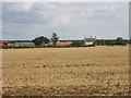
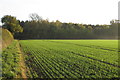
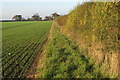
Pastures Farm, Yardley Hastings, seen across wheat stubble
View from public footpath which joins the road to Olney. The wheat has been cut recently.
Image: © David Hawgood
Taken: 13 Aug 2007
0.03 miles
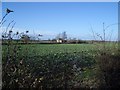
5
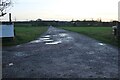
Track to Pastures Farm, Yardley Hastings
Image: © David Howard
Taken: 30 Oct 2022
0.14 miles