IMAGES TAKEN NEAR TO
West End, NORTHAMPTON, NN6 7AY
Introduction
This page details the photographs taken nearby to West End, NN6 7AY by members of the Geograph project.
The Geograph project started in 2005 with the aim of publishing, organising and preserving representative images for every square kilometre of Great Britain, Ireland and the Isle of Man.

There are currently over 7.5m images from over14,400 individuals and you can help contribute to the project by visiting https://www.geograph.org.uk
Image Map
Images are licensed for reuse under creativecommons.org/licenses/by-sa/2.0
Notes
- Clicking on the map will re-center to the selected point.
- The higher the marker number, the further away the image location is from the centre of the postcode.
Image Listing (113 Images Found)
Images are licensed for reuse under creativecommons.org/licenses/by-sa/2.0
Image
Details
Distance
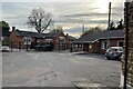
1
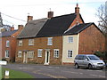
16-18 West End, West Haddon
These houses are grade II listed buildings. The listing describes them as 'probably early c18th'.
Image: © John Brightley
Taken: 23 Mar 2005
0.01 miles
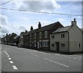
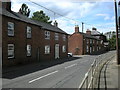
2
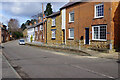
West End, West Haddon
This area is thought to have been originally developed in the 13th century at a time when West Haddon was a market town - a more important settlement than it is today. The counterpart to West End was South End although that name no longer exists. The attractive terraced houses here are considered notable for their slate roofs and this is part of the West Haddon conservation area. This stretch of road was part of the A428 between Rugby and Northampton but the village is by-passed now; note the raised pavement protected by a galvanised steel barrier.
Image: © Stephen McKay
Taken: 25 Feb 2022
0.02 miles
3
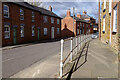
West End, West Haddon
The raised pavement along this stretch of West End is protected by a galvanised steel barrier which casts a shadow in the bright winter sunshine. This was a stretch of the A428 but the village is by-passed now.
Image: © Stephen McKay
Taken: 25 Feb 2022
0.02 miles
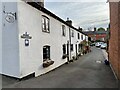
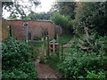
5
West Haddon-West End
Cottages near the centre of the Village.
Image: © Ian Rob
Taken: 20 Jun 2008
0.06 miles
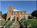
10
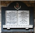
All Saints, West Haddon - Wall monument
Image: © John Salmon
Taken: 22 Aug 2012
0.07 miles