IMAGES TAKEN NEAR TO
Naseby, NORTHAMPTON, NN6 6BU
Introduction
This page details the photographs taken nearby to NN6 6BU by members of the Geograph project.
The Geograph project started in 2005 with the aim of publishing, organising and preserving representative images for every square kilometre of Great Britain, Ireland and the Isle of Man.

There are currently over 7.5m images from over14,400 individuals and you can help contribute to the project by visiting https://www.geograph.org.uk
Image Map
Images are licensed for reuse under creativecommons.org/licenses/by-sa/2.0
Notes
- Clicking on the map will re-center to the selected point.
- The higher the marker number, the further away the image location is from the centre of the postcode.
Image Listing (11 Images Found)
Images are licensed for reuse under creativecommons.org/licenses/by-sa/2.0
Image
Details
Distance
1
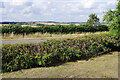
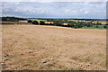
Fairfax's View
This was an important location in the Battle of Naseby of 1645 when the Parliamentarian New Model Army, under Sir Thomas Fairfax, decisively defeated Prince Rupert's Royalists, effectively bringing to an end the English Civil War. On the morning of 14th June Fairfax moved his army from Naseby Windmill (a site now commemorated with an obelisk) to this nearby vantage point. From here there was a clear view of the Royalist forces drawn up on the ridge across the valley. In those days the view would have been clearer without the hedgerows and woods we see now. A platform has been erected here so that the public can have a better idea of what the Parliamentarian commanders would have seen, together with interpretation boards and a small car park.
Image: © Stephen McKay
Taken: 21 Aug 2022
0.06 miles
2
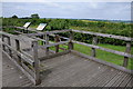
Fairfax's Viewpoint
The realignment of the road in front of Fairfax's Viewpoint has somewhat restricted the view from here. The site was Sir Thomas Fairfax's viewpoint during the battle of Naseby on 14 June 1645.
Image: © Philip Halling
Taken: 29 Jun 2013
0.06 miles
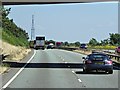
4

Eastbound A14, Refuge Area and Communications Mast near Naseby
Image: © David Dixon
Taken: 1 Aug 2013
0.07 miles
5
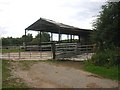
Naseby
Farm Buildings on the road to Newhouse Farm.
Image: © Ian Rob
Taken: 11 Aug 2006
0.09 miles
6
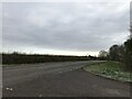
View over the site of the Battle of Naseby
This view over the site of the Battle of Naseby is roughly that viewed by Sir Thomas Fairfax on 14 June 1645. The official viewpoint is just to the south of a realigned road which now obscures much of this view.
Image: © Philip Halling
Taken: 15 Aug 2013
0.10 miles
8
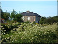
New-house Farm
No longer on a secluded back road, the busy A14 runs right in front of this farmhouse.
Image: © Alison Pryce
Taken: 5 Jun 2006
0.17 miles
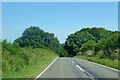
10
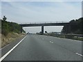
A14 - minor road overbridge at Naseby battlefield
Image: © Peter Whatley
Taken: 27 Jul 2013
0.22 miles