IMAGES TAKEN NEAR TO
Crescent Lodge, NORTHAMPTON, NN6 0SR
Introduction
This page details the photographs taken nearby to Crescent Lodge, NN6 0SR by members of the Geograph project.
The Geograph project started in 2005 with the aim of publishing, organising and preserving representative images for every square kilometre of Great Britain, Ireland and the Isle of Man.

There are currently over 7.5m images from over14,400 individuals and you can help contribute to the project by visiting https://www.geograph.org.uk
Image Map
Images are licensed for reuse under creativecommons.org/licenses/by-sa/2.0
Notes
- Clicking on the map will re-center to the selected point.
- The higher the marker number, the further away the image location is from the centre of the postcode.
Image Listing (5 Images Found)
Images are licensed for reuse under creativecommons.org/licenses/by-sa/2.0
Image
Details
Distance
1
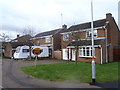
Ibstock Close
1980s houses on the edge of Northampton.
Image: © Burgess Von Thunen
Taken: 4 Feb 2016
0.10 miles
2
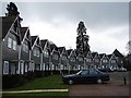
Houses at Overstone Park
Unusual development in the grounds of the Overstone Park http://www.overstonepark.com/ , constructed in timber.
Image: © Ian Paterson
Taken: 26 Mar 2008
0.16 miles
3
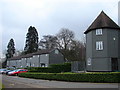
Overstone Park Hotel
The terrace on the left comprises a block of unusual two storey "hotel rooms" http://www.overstonepark.com/index.php?id=2&nest=1 of timber construction with a balcony behind. The tower shaped building to the right marks the end of the terraced houses in Image
Image: © Ian Paterson
Taken: 26 Mar 2008
0.16 miles
4

Goldenash Spinney
Spinney is behind an ivy-covered wall. Taken from across the road running south-east from Moulton to join the A5076.
Image: © Kokai
Taken: 12 Apr 2006
0.20 miles
5
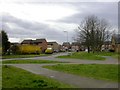
Southfields
A new estate on the north-east edge of Northampton. To the right of the image is seen part of one of the buildings of Southfields Farm. It is now used for business units.
Image: © Kokai
Taken: 12 Apr 2006
0.24 miles