IMAGES TAKEN NEAR TO
Millbrook Close, NORTHAMPTON, NN5 5JF
Introduction
This page details the photographs taken nearby to Millbrook Close, NN5 5JF by members of the Geograph project.
The Geograph project started in 2005 with the aim of publishing, organising and preserving representative images for every square kilometre of Great Britain, Ireland and the Isle of Man.

There are currently over 7.5m images from over14,400 individuals and you can help contribute to the project by visiting https://www.geograph.org.uk
Image Map
Images are licensed for reuse under creativecommons.org/licenses/by-sa/2.0
Notes
- Clicking on the map will re-center to the selected point.
- The higher the marker number, the further away the image location is from the centre of the postcode.
Image Listing (11 Images Found)
Images are licensed for reuse under creativecommons.org/licenses/by-sa/2.0
Image
Details
Distance
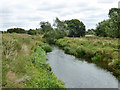
1
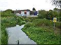
River Nene
Looking downstream, the sign is presumably for the benefit of canoes and similar, as this is above the limit of full size navigation.
Image: © Robin Webster
Taken: 4 Sep 2016
0.07 miles
2
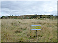
Private land no public access or right of way, 2016
Not long after, this was built on as an extension of the industrial zone here.
Image: © Robin Webster
Taken: 4 Sep 2016
0.07 miles
3
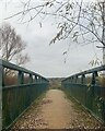
Bridge over the River Nene
The bridge leads from St. James towards Duston Mill reservoir, Northampton.
Image: © Rachel Cooley
Taken: 16 Dec 2021
0.08 miles
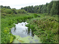
5
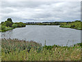
Duston Mill Reservoir
The River Nene in times of flood overspills into it at the far end, so it is really a holding pond as well as an amenity.
Image: © Robin Webster
Taken: 4 Sep 2016
0.13 miles
6
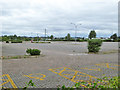
Large car park, newish but unused
What was the idea? Is it for the industrial area?
Image: © Robin Webster
Taken: 4 Sep 2016
0.14 miles
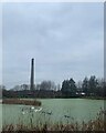
7
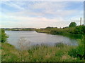
Nene Valley
Former gravel pits. The National Lift Tower can be seen on the right-hand side.
Image: © Burgess Von Thunen
Taken: 25 Jul 2011
0.16 miles
8
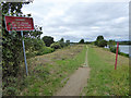
Footpath liable to flooding, Nene valley
The path runs between a flood relief channel on the left and a large holding lake or reservoir. The natural course of the river runs on the north side of the lake.
Image: © Robin Webster
Taken: 4 Sep 2016
0.18 miles
9
Relief channel, River Nene
This passes to the south of a large holding lake, the natural course of the river passes to the north.
Image: © Robin Webster
Taken: 4 Sep 2016
0.18 miles
10
Sharman's Lake and The Express Lift Tower
Small lake located in St. James, Northampton. Close to Franklin's Gardens, home of the Northampton Saints Rugby Union Team. The National Express Lift Tower standing in the distance, this is a grade 2 listed building.
Image: © Rachel Cooley
Taken: 16 Dec 2021
0.21 miles