IMAGES TAKEN NEAR TO
Emley Close, NORTHAMPTON, NN3 9SH
Introduction
This page details the photographs taken nearby to Emley Close, NN3 9SH by members of the Geograph project.
The Geograph project started in 2005 with the aim of publishing, organising and preserving representative images for every square kilometre of Great Britain, Ireland and the Isle of Man.

There are currently over 7.5m images from over14,400 individuals and you can help contribute to the project by visiting https://www.geograph.org.uk
Image Map
Images are licensed for reuse under creativecommons.org/licenses/by-sa/2.0
Notes
- Clicking on the map will re-center to the selected point.
- The higher the marker number, the further away the image location is from the centre of the postcode.
Image Listing (13 Images Found)
Images are licensed for reuse under creativecommons.org/licenses/by-sa/2.0
Image
Details
Distance
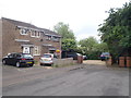
1
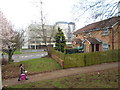
Weston Favell
A footpath alongside cluster homes in Emley Close with the telephone exchange behind.
Image: © Burgess Von Thunen
Taken: 12 Mar 2014
0.02 miles
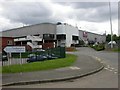
2
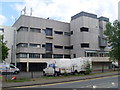
Telephone Exchange, Weston Favell
Situated at the junction of the A4500 Wellingborough Road and Billing Brook Road, this modern looking TE serves customers in the eastern area of Northampton. Its postcode is NN3 9HH.
Image: © David Hillas
Taken: 20 Jun 2009
0.06 miles
3
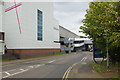
Weston Favell Centre
Looking along Billing Brook Road where it passes the sizeable out-of-town shopping centre, deep in Northampton's eastern suburbs. The stylised cross represents the Emmanuel Church, a multi-denominational church which is part of the centre.
Image: © Stephen McKay
Taken: 20 Sep 2017
0.12 miles
4
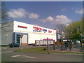
Weston Favell Shopping Centre
South side.
Image: © Burgess Von Thunen
Taken: 21 Apr 2010
0.14 miles
5
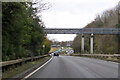
Footbridge over A43 Lumbertubs Way
A curious design, with the long spans not sharing a column and overall looking more like a pipe bridge. It leads from a residential area on the right to Weston Favell shopping centre on the left, entering it at the same high level.
Image: © Robin Webster
Taken: 5 Dec 2021
0.17 miles
6
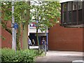
Entrance to Lings Forum
Lings Forum, run by Northampton Borough Council, is a leisure centre including a swimming pool and an alternative cinema showing films that do not enjoy wide appeal in the local cinema complexes - for instance the occasional South Korean movie and some gay films.
Image: © Kokai
Taken: 23 May 2006
0.18 miles
7
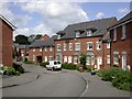
Ashmead Housing Estate
Ashmead appears to be very new and is not yet shown on the latest OS map.
Image: © Kokai
Taken: 23 May 2006
0.18 miles
8
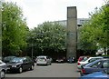
Emmanuel Church
A shared church - Baptist, Church of England, Methodist and United Reformed. The church is part of the Weston Favell shopping centre to which it attaches via its bridge, seen on the right of the image. Photo taken from the Lings Forum car park. The entrance to Lings Forum is in deep shadow to the left of the image and I am submitting another image to cover that.
Image: © Kokai
Taken: 23 May 2006
0.19 miles
9
Weston Favell Shopping Centre
The signpost in the foreground of the image, 'Northampton Academy', is giving directions to a nearby school.
Image: © Kokai
Taken: 23 May 2006
0.21 miles
10
Middlewell Court
1980s semis in Standens Barn.
Image: © Burgess Von Thunen
Taken: 13 Jun 2016
0.22 miles