IMAGES TAKEN NEAR TO
Arbour Court, NORTHAMPTON, NN3 8HB
Introduction
This page details the photographs taken nearby to Arbour Court, NN3 8HB by members of the Geograph project.
The Geograph project started in 2005 with the aim of publishing, organising and preserving representative images for every square kilometre of Great Britain, Ireland and the Isle of Man.

There are currently over 7.5m images from over14,400 individuals and you can help contribute to the project by visiting https://www.geograph.org.uk
Image Map (Loading...)


Getting Data...Please wait
Leaflet Map data © OpenStreetMap
Images are licensed for reuse under creativecommons.org/licenses/by-sa/2.0
Notes
- Clicking on the map will re-center to the selected point.
- The higher the marker number, the further away the image location is from the centre of the postcode.
Image Listing (18 Images Found)
Images are licensed for reuse under creativecommons.org/licenses/by-sa/2.0
Image
Details
Distance
2
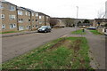
Old Quarry Court
1970s council houses in Lumbertubs.
Image: © Burgess Von Thunen
Taken: 20 Dec 2013
0.06 miles
5
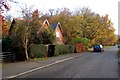
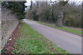
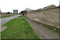
Heather Lane, Billing Arbours
Looking south down Heather Lane towards Tonmead Road and Weston Favel Centre. Before the development of this area in the 1970s, this lane was the road from Moulton to Little Billing, but has now been cut off by the A43 Lumbertubs Way. The modern pedestrian footpath to Weston Favell follows the original line of the road. The houses on Heather Lane were built in 1987/88 on land which was originally attached to Billing Arbours House, now in use as a commercial centre.
Image: © John Mitchell
Taken: 15 Nov 2008
0.15 miles
6
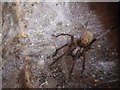
A spider
Underneath a man-hole cover.
Image: © Burgess Von Thunen
Taken: 30 Oct 2015
0.16 miles
7
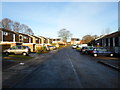
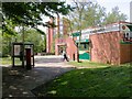
Rickyard Road
1970s houses in The Arbours.
Image: © Burgess Von Thunen
Taken: 30 Oct 2015
0.16 miles
8
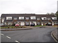
Brookside Shopping Centre
A very compact set of facilities. Costcutter in the foreground is the Post Office, Supermarket and Newsagent. Behind it is a Chinese Takeaway that also sells fish and chips. There is also a pub, the Mill Wheel, opposite and the Community Centre is close by.
Image: © Kokai
Taken: 23 May 2006
0.17 miles
10
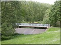
Bridge and Weir, Billing Arbours
Taken from the road which runs north along the east side of the Arbours. The weir is at the south end of the lake.
Image: © Kokai
Taken: 23 May 2006
0.19 miles