IMAGES TAKEN NEAR TO
The Avenue, NORTHAMPTON, NN3 7TL
Introduction
This page details the photographs taken nearby to The Avenue, NN3 7TL by members of the Geograph project.
The Geograph project started in 2005 with the aim of publishing, organising and preserving representative images for every square kilometre of Great Britain, Ireland and the Isle of Man.

There are currently over 7.5m images from over14,400 individuals and you can help contribute to the project by visiting https://www.geograph.org.uk
Image Map (Loading...)


Getting Data...Please wait
Leaflet Map data © OpenStreetMap
Images are licensed for reuse under creativecommons.org/licenses/by-sa/2.0
Notes
- Clicking on the map will re-center to the selected point.
- The higher the marker number, the further away the image location is from the centre of the postcode.
Image Listing (6 Images Found)
Images are licensed for reuse under creativecommons.org/licenses/by-sa/2.0
Image
Details
Distance
1
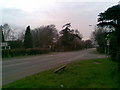
A43
Where Thorpeville becomes Park View. You won't normally see it this quiet.
Image: © Burgess Von Thunen
Taken: 7 Apr 2010
0.05 miles
2
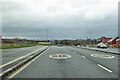
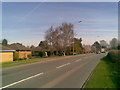
A43 heading south
The 40 limit on an apparently high speed road is an indication, together with some as yet blind turnings, that further housing development is anticipated.
Image: © Robin Webster
Taken: 5 Dec 2021
0.11 miles
3
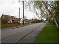
Ashley Lane
Bungalows in Moulton.
Image: © Burgess Von Thunen
Taken: 7 Apr 2014
0.11 miles
4
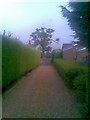
Park View
A private drive leading out to the A43.
Image: © Burgess Von Thunen
Taken: 26 Jul 2010
0.13 miles
5
Park View
Predominantly large 1980s-built bungalows looking towards Overstone Park.
Image: © Burgess Von Thunen
Taken: 13 Apr 2010
0.16 miles
6
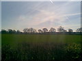
Farmland near Overstone
Looking towards a tree-lined road to Overstone.
Image: © Burgess Von Thunen
Taken: 13 Apr 2010
0.16 miles