IMAGES TAKEN NEAR TO
Tower Field Square, NORTHAMPTON, NN3 5BE
Introduction
This page details the photographs taken nearby to Tower Field Square, NN3 5BE by members of the Geograph project.
The Geograph project started in 2005 with the aim of publishing, organising and preserving representative images for every square kilometre of Great Britain, Ireland and the Isle of Man.

There are currently over 7.5m images from over14,400 individuals and you can help contribute to the project by visiting https://www.geograph.org.uk
Image Map
Images are licensed for reuse under creativecommons.org/licenses/by-sa/2.0
Notes
- Clicking on the map will re-center to the selected point.
- The higher the marker number, the further away the image location is from the centre of the postcode.
Image Listing (5 Images Found)
Images are licensed for reuse under creativecommons.org/licenses/by-sa/2.0
Image
Details
Distance
1
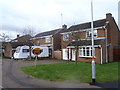
Ibstock Close
1980s houses on the edge of Northampton.
Image: © Burgess Von Thunen
Taken: 4 Feb 2016
0.14 miles
2
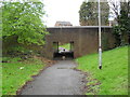
Goldings
An underpass under Goldings Road.
Image: © Burgess Von Thunen
Taken: 9 Apr 2012
0.17 miles
3
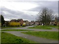
Southfields
A new estate on the north-east edge of Northampton. To the right of the image is seen part of one of the buildings of Southfields Farm. It is now used for business units.
Image: © Kokai
Taken: 12 Apr 2006
0.17 miles
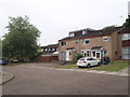
4
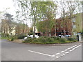
Crestline Court
1970s council flats in Goldings.
Image: © Burgess Von Thunen
Taken: 6 May 2016
0.19 miles
5
Saruman Lane
1970s council houses in Overstone Lodge. All the roads on this estate are named after things from Lord of the Rings. I wouldn't want to live on Saruman Lane though because he was an evil wizard. Luckily, they didn't name any of the roads after Shelob, the giant spider. Etc.
Image: © Burgess Von Thunen
Taken: 15 Jul 2015
0.21 miles