IMAGES TAKEN NEAR TO
Hardwater Road, WELLINGBOROUGH, NN29 7TB
Introduction
This page details the photographs taken nearby to Hardwater Road, NN29 7TB by members of the Geograph project.
The Geograph project started in 2005 with the aim of publishing, organising and preserving representative images for every square kilometre of Great Britain, Ireland and the Isle of Man.

There are currently over 7.5m images from over14,400 individuals and you can help contribute to the project by visiting https://www.geograph.org.uk
Image Map
Images are licensed for reuse under creativecommons.org/licenses/by-sa/2.0
Notes
- Clicking on the map will re-center to the selected point.
- The higher the marker number, the further away the image location is from the centre of the postcode.
Image Listing (5 Images Found)
Images are licensed for reuse under creativecommons.org/licenses/by-sa/2.0
Image
Details
Distance
4
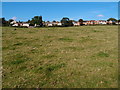
Great Doddington
The line of houses get a great view of the Nene Valley and quite a few have balconies built on to make the most of the scenery. Viewed from the Nene Way footpath.
Image: © Michael Trolove
Taken: 7 Oct 2012
0.14 miles