IMAGES TAKEN NEAR TO
Cobblers Place, WELLINGBOROUGH, NN29 7HH
Introduction
This page details the photographs taken nearby to Cobblers Place, NN29 7HH by members of the Geograph project.
The Geograph project started in 2005 with the aim of publishing, organising and preserving representative images for every square kilometre of Great Britain, Ireland and the Isle of Man.

There are currently over 7.5m images from over14,400 individuals and you can help contribute to the project by visiting https://www.geograph.org.uk
Image Map
Images are licensed for reuse under creativecommons.org/licenses/by-sa/2.0
Notes
- Clicking on the map will re-center to the selected point.
- The higher the marker number, the further away the image location is from the centre of the postcode.
Image Listing (7 Images Found)
Images are licensed for reuse under creativecommons.org/licenses/by-sa/2.0
Image
Details
Distance
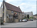
1
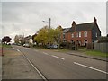
London Road, Bozeat, looking South
This is a view of London Road, Bozeat, looking south. This was a busy main route through the village, including traffic heading between Wellingborough and the M1, until the village was eventually given a bypass that was officially opened on 1st February 1989.
Image: © Nigel Stickells
Taken: 15 Nov 2006
0.03 miles

7
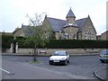
The Old School, Camden Square, Bozeat
The Old School in Camden Square was erected in 1873. It closed 100 years later on 1 May 1973 after a new school had been built. The Old School was sold off privately and converted into three domestic dwellings.
Image: © Nigel Stickells
Taken: 15 Nov 2006
0.24 miles