IMAGES TAKEN NEAR TO
Wantage Road, WELLINGBOROUGH, NN29 7HE
Introduction
This page details the photographs taken nearby to Wantage Road, NN29 7HE by members of the Geograph project.
The Geograph project started in 2005 with the aim of publishing, organising and preserving representative images for every square kilometre of Great Britain, Ireland and the Isle of Man.

There are currently over 7.5m images from over14,400 individuals and you can help contribute to the project by visiting https://www.geograph.org.uk
Image Map
Images are licensed for reuse under creativecommons.org/licenses/by-sa/2.0
Notes
- Clicking on the map will re-center to the selected point.
- The higher the marker number, the further away the image location is from the centre of the postcode.
Image Listing (21 Images Found)
Images are licensed for reuse under creativecommons.org/licenses/by-sa/2.0
Image
Details
Distance
1
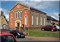
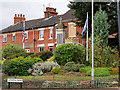
Irchester: Methodist Church
The church was built as a Wesleyan Chapel in 1869 and the bunting outside reflects the celebration of its 150th anniversary in 2019. The building to the rear is a later extension.
Image: © Nigel Cox
Taken: 14 Jun 2019
0.08 miles
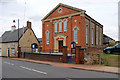
4
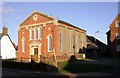
The Wesleyan Chapel
Built in 1879 in the village of Irchester.
Image: © Kokai
Taken: 24 Oct 2006
0.10 miles
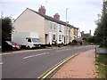
6
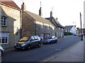
High Street, Irchester
Early evening in Autumn produces tall shadows here. The road to the left, past the thatched house on the corner, leads to Knuston Hall and Rushden Town.
Image: © Kokai
Taken: 24 Oct 2006
0.12 miles
7
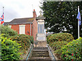
War Memorial, Irchester
Irchester War Memorial, which was unveiled in 1920, stands in a small elevated railed memorial garden off High Street. It is Grade II-listed (List entry Number: 1428261 https://historicengland.org.uk/listing/the-list/list-entry/1428261 Historic England)
The war memorial comprises a 5m tall, square-sectioned, pillar surmounted by a capstone with an out-sailing cornice, on which is raised a domed cap. A small Latin cross rises from the top.
A large slate panel to the front face is inscribed OUR GLORIOUS DEAD, with the names of the 76 fallen beneath. ‘FOR EVER IN OUR THOUGHTS’ is inscribed below. On the stage beneath the main pillar a slate panel is inscribed WORLD WAR II. 1939 - 1945 (17 names). A slate panel on the rear of the pillar is inscribed ERECTED/ BY/ PUBLIC SUBSCRIPTION/ IN GRATEFUL MEMORY/ OF THE IRCHESTER MEN/ WHO GAVE THEIR LIVES/ FOR THEIR COUNTRY/ IN/ THE GREAT WAR/ 1914 – 1919. A sloping stone panel at the base of the front of the monument commemorates nine villagers killed in an air raid on 20 May 1941.
The memorial is approached by steps flanked by metre-high limestone walls. Around it is a sloping memorial garden contemporary with the memorial, defined by iron railings; decorative gates give access to the steps. Two modern flagpoles have been erected either side of the memorial at the top of the garden.
Image: © David Dixon
Taken: 4 Sep 2016
0.13 miles
8
Irchester War Memorial
Irchester War Memorial, which was unveiled in 1920, stands in a small elevated railed memorial garden off High Street. It is Grade II-listed (List entry Number: 1428261 https://historicengland.org.uk/listing/the-list/list-entry/1428261 Historic England)
The war memorial comprises a 5m tall, square-sectioned, pillar surmounted by a capstone with an out-sailing cornice, on which is raised a domed cap. A small Latin cross rises from the top.
A large slate panel to the front face is inscribed OUR GLORIOUS DEAD, with the names of the 76 fallen beneath. ‘FOR EVER IN OUR THOUGHTS’ is inscribed below. On the stage beneath the main pillar a slate panel is inscribed WORLD WAR II. 1939 - 1945 (17 names). A slate panel on the rear of the pillar is inscribed ERECTED/ BY/ PUBLIC SUBSCRIPTION/ IN GRATEFUL MEMORY/ OF THE IRCHESTER MEN/ WHO GAVE THEIR LIVES/ FOR THEIR COUNTRY/ IN/ THE GREAT WAR/ 1914 – 1919. A sloping stone panel at the base of the front of the monument commemorates nine villagers killed in an air raid on 20 May 1941.
The memorial is approached by steps flanked by metre-high limestone walls. Around it is a sloping memorial garden contemporary with the memorial, defined by iron railings; decorative gates give access to the steps. Two modern flagpoles have been erected either side of the memorial at the top of the garden.
Image: © David Dixon
Taken: 4 Sep 2016
0.13 miles
9
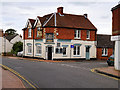
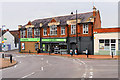
The 19th, Irchester High Street
Public house and restaurant on High Street. Previously called "The Red Lion".
Image: © David Dixon
Taken: 4 Sep 2016
0.14 miles
10
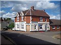
Irchester: Former Red Lion Inn and former 19th
This public house, on the corner of the High Street and Townwell Lane, was originally the Red Lion Inn, and latterly the 19th, as photographed by David Dixon in September 2016 Image It has since been closed and is boarded up.
Image: © Nigel Cox
Taken: 14 Jun 2019
0.14 miles