IMAGES TAKEN NEAR TO
Arkwright Road, WELLINGBOROUGH, NN29 7EF
Introduction
This page details the photographs taken nearby to Arkwright Road, NN29 7EF by members of the Geograph project.
The Geograph project started in 2005 with the aim of publishing, organising and preserving representative images for every square kilometre of Great Britain, Ireland and the Isle of Man.

There are currently over 7.5m images from over14,400 individuals and you can help contribute to the project by visiting https://www.geograph.org.uk
Image Map
Images are licensed for reuse under creativecommons.org/licenses/by-sa/2.0
Notes
- Clicking on the map will re-center to the selected point.
- The higher the marker number, the further away the image location is from the centre of the postcode.
Image Listing (5 Images Found)
Images are licensed for reuse under creativecommons.org/licenses/by-sa/2.0
Image
Details
Distance
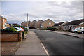
2
Station Road
The outskirts of Irchester. The X46 bus, carrying passengers between Raunds and Northampton, approaches the corner.
Image: © Kokai
Taken: 9 Nov 2006
0.16 miles
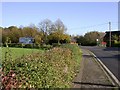
4
Footpath to Irchester
Crosses two fields between Station Road and the old part of the village.
Image: © Kokai
Taken: 9 Nov 2006
0.22 miles
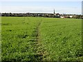
5
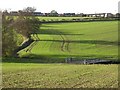
View towards Irchester
A relatively new part of the village is visible. The footbridge at the bottom of the slope carries farm machinery, as well as walkers, across the brook.
Image: © Kokai
Taken: 9 Nov 2006
0.23 miles